Friday, June 19, 2020

Geologic stories at Peanaccle Point.

When my dad asked me if I would like to tag along with him and my brother on a climbing day trip in the western Cascades, I took it up immediately. I haven't had a whole lot of opportunities to go adventuring lately, so I was eager to stretch my legs. 

The approach to the Peannacle Point area is brutal, there's a reason it's mainly climbers that travel to this isolated outcrop. From the trailhead, it's about 1800 feet elevation gain in 1.5 miles, mostly following the Mt. Washington trail until the last half mile or so. The trail leads unrelentingly up the mountainside, winding through a forest of Douglas Fir, Hemlock, Cedar, and Red Alder, with the symphonies of summer wrens and warblers echoing through the canopy. After leaving the main trail, the climbers boot bath scrambles up through some dense brush, over some fallen trees, and through gaps in the rocky terrain. You eventually pop out into an open area of large talus in the shadow of The Peannacle, a small jutting tower of orange-tan rock nearly 2,000 feet above the valley floor. 


The Peannacle from the base. 

The view from here is spectacular, looking west you can catch sight of the Puget Sound, straight ahead is the yawning Snoqualmie Valley, and to the right is the rugged peaks of the Cascade Range. Intertwined with these are all the geologic stories you can see laid before you. 

Filling large portions of the Snoqualmie valley below is a series of large, flat plateaus, several of which have active pit mines. These tablelands collectively make up Grouse Ridge, the remnants of an ice age moraine formed by the Puget Lobe of the Cordilleran Ice Sheet as it advanced from the Puget Lowland up the Snoqualmie Valley. The meltwater streams issuing from the Puget Lobe deposited the sand, gravel, and glacial erratics making up Grouse Ridge in front of it. 

Mount Si with the flat-topped Grouse Ridge Moraine in front. 

Mount Si itself, rising across the valley and behind Grouse Ridge, is another story. Mount Si is made of what's known as a melange, a blended mixture of different rock types swirled together in a chaotic mass. The rocks making of Mount Si are far older than any of the volcanic rocks in the Cascade Range, being emplaced well over 66 million years ago. 

The rock of Peannacle Point itself was an enigma for most of the day. When I first visited this site before my CWU Geology education, I took one look at the rock and proclaimed that it was part of the Snoqualmie Batholith, a granite. I was under that same conclusion at the beginning of this excursion again, until I started looking at the rock closer. As my dad and brother scaled the different faces, I slowly realized I wasn't looking at granite at all. I was looking at something entirely different. The rock at Peannacle Point is a breccia. Breccia is a type of rock formed by gravel or boulders of various other rock types being cemented together in a fine-grained matrix. This is precisely what I saw as I took a close look at different places on the outcrop; to my dismay, I realized I had been a sucker. This wasn't the Snoqualmie Batholith at all; this was part of the Ohanapecosh Formation. 

Cell phone photo of the Breccia of Peannacle Point. Note the rock pieces visible above the camera lens and the large, greenish clast in the top right corner. 

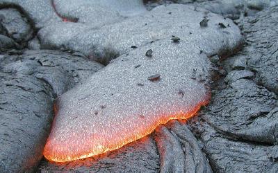
The Ohanapecosh Formation is a thick pile of sedimentary rocks laid down as a direct result of the volcanic activity of early Cascade Volcanoes. A large portion of the Ohanapecosh Formation, including rocks that make up the cliffs of Peannacle Point, is a result of violent volcanic events known as pyroclastic flows. Pyroclastic flows are avalanches of superheated gas, rock, ash, and other volcanic material that cascades down the side of a volcano during an explosive eruption. The early Cascade Volcanoes were highly explosive, probably erupting multiple pyroclastic flows that, at that time, only flowed a short distance down the volcano's slopes before plunging into the Pacific Ocean, which lapped at the volcano's feet. The deposition of pyroclastic flows into water forms breccia, like the breccia found in the Ohanapecosh Formation. 

A pyroclastic flow entering the ocean. Photo courtesy of the British Geological Survey. 

The deposition of the Ohanapecosh Formation occurred between approximately 38 and 25 million years ago. As it turns out, this time is roughly concurrent with the deposition of our dear friend, the Blakeley Formation. Could it be possible that the Ohanapecosh Formation was deposited onto a continental shelf as pyroclastic flows and other volcanic debris crashed into the sea, and when that material demobilized or continued into deeper water, it began to construct a thick undersea fan, settling into distinct, well-sorted layers, building the Blakeley Formation? I think it's more than possible, however, the evidence that I'm establishing for that and my reasoning will have to wait for another post. It's always fun to find something so far from home that might have a connection to the rocks which are just beneath our feet. 

Until the next adventure!  


Thursday, June 4, 2020

A New Perspective: The Ecologic and Geologic Oasis of Stephenson Canyon, Bremerton.

A sudden wave of nostalgia washed over me as I followed my friend and Kitsap Sun reporter Josh Farley into the depths of Stephenson Canyon. I had last stepped foot here over five years ago, at the very start of the "Kitsap Waterfall Survey" project. 

The canyon was filled with various shades of greens and browns, exploding with the growth of mid-spring. Carpets of sword ferns filled the understory, with large Big-Leaf Maples, Western Red Cedars, and Douglas Firs creating the canopy a hundred feet above our heads. And of course, down at the bottom, Stephenson Creek chattered away, beckoning. 

A "pocket wilderness" inside Bremerton city limits. 

I've learned so much since I first stepped into the canyon. In 2015 I couldn't have cared less what kind of plants and ecology the canyon hosted; I only cared about rocks. Now, I was taking it all in through a new set of skills and experiences. I looked up and around as well as down, remarking the enigma of such a beautiful Pacific Northwest oasis in the middle of a significant city. Craig Romano described it well in Urban Trails: Kitsap when he called it "...a pocket wilderness that feels like it can be deep in the Olympics." 

Of course, it wasn't entirely without flaw. Invasive English Ivy besieged several trees on the rim and down into the canyon, and trash and old city refuse was abundant. A community cleanup effort here would probably breathe some new life into the area, and the city would do well to pay more attention and protect this beautiful piece of borderline old-growth ecosystem. 

Moving on, we descended into the canyon and crossed the creek, moving our eyes away from the canopy and down to the ground. Various cobbles and boulders lined the stream channel, and the footpath traversed some small but textbook stream terraces that probably get a new layer of sand and mud every time the creek floods. 

Our main destination, of course, was "Stephenson Canyon Falls." The little cascade I "discovered" so many years ago. We rounded the corner, and the first words that flashed into my head were, "I'm an idiot." 

Back in 2015, I had no geology education other than a couple basic geology classes, and I hadn't done a whole lot of research on the geology of the bedrock underlying the Kitsap Peninsula. The extent of my knowledge was that most of the bedrock in the area was basalt. So I had assumed that the falls dropped over basalt. I was dead wrong. 

"Stephenson Canyon Falls" with slightly dipping beds of the Blakeley Formation
"Stephenson Canyon Falls" with slightly dipping beds of the Blakeley Formation. The Falls drop over possible sandstone, while the satchel sits on mudstone/siltstone.

"Stephenson Canyon Falls" actually drops over a resistant ledge of the "Blakeley Formation," a much younger rock with a completely different origin than the basaltic rock that makes up the Blue Hills. The area around the falls exposes two types of rock within the Blakeley Formation. The base of the falls is made up of siltstone or mudstone, and the falls themselves drop over what might be a sandstone with larger softball-sized class embedded within it. I have my own interpretations of what this layer might be, but I'm going to hold off on that until a later date after I do more research. 

Downstream of the falls, Stephenson Creek flows over and alongside some of the nicest Glacial Till deposits that I've seen on the Peninsula. Blue Gray concrete-like deposits form shelves and small embankments, peppered with glacial erratics and small potholes drilled during times of flooding or high water.


An exposure of glacial till with a carved pothole at the bottom of Stephenson Canyon. 

After viewing the falls and surrounding geology, it was time for Josh to head back. We made our way downstream again, where we stumbled upon an absolutely titanic Douglas Fir Tree, possibly an old-growth giant from before the first caucasian colonists arrived in Western Washington. It was a sight to behold and was a great symbol that despite the surrounding urban sprawl, Stephenson Canyon is still very much wild. 

Friday, May 15, 2020

Chasing Erratics on the Great (Kitsap) Peninsula.

Yesterday I decided to go on a little adventure and investigate some of the known glacial erratics that I had heard of on the Great (Kitsap) Peninsula, specifically in the Illahee Area.

A glacial erratic is a piece of rock that differs from the size and type of native rock in the area on which it rests. They are carried by glacial ice, often hundreds of miles. Erratics can be as small as pebbles or larger than a building.

Erratics are common on the Great (Kitsap) Peninsula because this area has been subject to half a dozen or more glaciations over the past 2 million years, with the last one ending 16,000 years ago. During these glaciations, a large tongue of ice known as the Puget Lobe advanced south to fill the Puget Lowland as far as Olympia. Over the Great Peninsula, it was probably well over 2,000 feet thick! More than enough to flow entirely over the top of Green Mountain and the rest of the Blue Hills.

The extent of the Puget Lobe of the Canadian ice sheet. Photo courtesy of Washington DNR. 
Since this glacier came from the north, originating in southern Canada, it was plucking pieces of rocks off the mountains there. The rock types found in the Canadian Rockies and coast ranges are much different than those found here on the Great and Olympic Peninsulas, mostly granites and metamorphic rocks. Our hard bedrock here is either igneous rock of the Blue Hills or sedimentary rock of the Blakeley Formation. So if you see a granitic rock somewhere on the Peninsula, whether it be your yard, a beach, or a park, you can assume it's a glacial erratic.

We likely have hundreds if not thousands of significant glacial erratics on our peninsula. Most of them are probably buried beneath the surface, trapped in the thick glacial formations. This point was illustrated to me quite nicely when I was watching a well being drilled near Central Valley, it encountered a glacial erratic along the way down, and suddenly shards and flakes of beautiful granite came flying out!

However, there are some sizable erratics on the surface that you can find. Yesterday I found 3, which are listed below.

  • Ther is a glacial erratic in the Almira Drive parking lot for the Illahee Preserve in East Bremerton. This is a metamorphic rock showing smooth surfaces probably polished by glacial ice as it was transported. 
The Illahee Erratic, with a telephone pole for scale. 
  • There is a large glacial erratic on the east side of Illahee road just as the road begins to drop towards the coast traveling northbound. This is one of the largest erratics I have seen on the Peninsula. And interestingly. It is not granitic or metamorphic, it appears to be a large chunk of basalt, which means it may have been plucked from the Olympic Mountains.
  • On the corner of Trenton Ave and Fernwood Street, in a lucky person's front yard, is a huge glacial erratic of Blue-Gray volcanic rock suspiciously similar looking to the rocks found in the Blue Hills. Perhaps it was plucked off of Green Mountain or one of the surrounding summits? The best viewing for this erratic is in the pullout on the west side of Trenton Ave, please respect the landowner's property by not attempting to go into their yard. 

These are just a few of the many significant erratics that are scattered around the peninsula, as I stumble across more, if they are substantial enough, I will do a write up for them too. I know there are several in North Kitsap, so perhaps I'll go explore up there sometime in the near future. Summer is just around the corner, and geologic adventures are everywhere in Washington State and the Great Peninsula!

Monday, May 4, 2020

What is Geyser Gazing?


Almost every facet of nature has a "fan club" or community of hobbyists associated with it: bird watchers, mycophagists, rockhounds, storm chasers, etc. In Yellowstone National Park (and occasionally other places with hydrothermal activity), you can find the geyser gazers. 

Image may contain: one or more people, people standing, ocean, outdoor and water
The author and another gazer enjoying an eruption of Fan and Mortar Geysers in 2014. Photo by Mara Reed.

People who identify themselves as geyser gazers have a variety of reasons that they enjoy spending long periods watching and studying geysers. Some do it for research purposes, collecting and analyzing data on behavior, patterns, and connections with other features unofficially or officially. Others do it with a camera in hand, always striving to get a great shot of these geologic fireworks. Some are in it mostly for the social aspect, hanging out with good friends and enjoying camaraderie while waiting for nature's show. Adrenaline junkies are present, chasing the adrenaline-fueled pandemonium during eruptions of massive and rare geysers. And some people practice the hobby as a way to enjoy a unique aspect of nature. But, to put this all together in a simple sentence, being a geyser gazer boils down (pun intended) to being someone that has a specific passion for geysers. This manifests itself in the many ways listed above, and others.

No photo description available.
One of the now-extinct geysers at Steamboat Springs, Nevada. Photo by Rocco Paperiello.

There are many reasons why geysers are probably one of the unique geologic features on the planet and deserve attention. There are fewer than 3,000 of these erupting springs on the globe. Naturally, their numbers wax and wane almost weekly, with new geysers forming and erupting and others ceasing activity and going dormant or extinct. But, in addition to their natural fluctuations, recent human developments also severely threaten geysers. Drilling for geothermal power and oil, the construction of hydroelectric dams, as well as other projects, have destroyed or severely impacted several hydrothermal fields around the world in the past several decades. Geysers over 30 feet high were present above highway 395 in Nevada, just outside of Reno, before the Steamboat Springs geothermal powerplant went online in 1986 and snuffed them out forever. Their rarity, combined with the current anthropogenic threat, is what makes geysers the endangered species of geology.

Castle Geyser erupts at Sunrise. 

It's impressive enough that, in specific instances, the laws of physics and geology operate in such a way to propel boiling water into the air, it's even more fascinating when you realize that many of these features have discernable patterns to them. Some geysers erupt so regularly that you can nearly set your watch by them. On the opposite end of the spectrum, some geysers seemingly operate on a geologic coin flip, erupting erratically and seemingly randomly. But the latter chaotic side also gives them an allure. Most geysers do not play on a predictable schedule; some erupt days, weeks, months, or even years apart. The high regularity of Old Faithful is the exception rather than the norm. Another level to this is that this irregularity my be in part because many geysers are connected with other hydrothermal features, creating fascinating interplay, like a pool draining during an eruption, or activity in one geyser heralding, or even triggering, the eruptions or activity of another.

Every 200-foot major eruption of Giant Geyser (The huge cone) is preceded by a Giant Hot Period (surrounding activity), but not every hot period ends in a Giant Eruption. Talk about suspense!

There are persons from many walks of life in the geyser gazing community; teens, college students, moms and dads, retirees, etc. Gazers often congregate while waiting for the next geyser eruption, whether it be large or small, common or rare. Those times are frequently filled with laughter and happiness, stories and data are exchanged, jokes are quipped, and theories debated while waiting for the eruption. But gazers will have their specific individual interests as well. Some go towards Geyser Hill near Old Faithful or watch a particular geyser or several related ones. Others are content to go off into the far corners of the basin to wait on more erratic and unpredictable, but relatively quiet, geysers. Still, others prefer specific geyser basins around the park.

Gazers wait for an eruption of Steamboat Geyser.
Standing or sitting for long periods watching a geyser or other hydrothermal feature tends to attract attention, especially when you have a radio and notebook in your hands. Of the plethora of questions you receive, many commonly revolve around the theme of: "Why are you doing this?" Which is essentially asking, "What is geyser gazing?"

Geyser gazing is the person screaming for the big geyser, the person in the hat and sunglasses quietly sitting with a notebook by a spring, It's the person pulled over off the side of the road staring at some steam in the distance. Or it's the person leading an energetic explanation to a group of visitors about why they need to wait five more minutes and get the show of their lives. Geyser gazing is a passion for geysers and any form that takes. If you look for it, you'll see it, and maybe you'll become a part of it. 


Monday, April 13, 2020

Micah's Big Three

Once I take a liking to something, I tend to hyperfocus on it, sometimes to the point of obsession. This applies to hobbies, movies, food, books, and especially geologic features.

Over the past seven years, I have found three geographic features that have consistently captured my interest, bring me excitement, and that I love to talk about. Those three are geysers, waterfalls, and natural arches.

Geysers are the first feature that drew my attention. Back in 2012, I visited Yellowstone for a week and fell into the midst of the Geyser Gazers. Geysers instantly entranced me for their variation, patterns, activity, and uniqueness. I have now studied geysers and their associated hydrothermal features since, and it's something I plan to do for a long time.

Image may contain: one or more people, people standing, sky, cloud, outdoor, nature and water
The author observing an eruption of Beehive Geyser, photo by Cris Gower. 
The second geologic feature that ensnared me was an indirect result of geysers. In 2014, a good friend of mine talked two other friends and me into a three-day backpacking trip into a remote section of Yellowstone National Park known as the Bechler Region to view and photograph three world-class waterfalls. The trip was a chaotic blend of awesome and misery, but I came out of it with a new fondness of water going up as well as water going down. I kicked off the Kitsap Waterfall Survey just four months later.

No photo description available.
The author at "Tin Mine Falls", Kitsap County. Photo by Rocco Paperiello.
The third geologic feature is the most recent, and one that took me somewhat by surprise. This last Fall (2019) after the end of my Yellowstone summer employment, I took a road trip through central Utah. I always wanted to go to Utah to view its amazing geologic landscapes and formations. Several people told me before the trip that it would become my favorite state, and that I might gain another feature that I was obsessed with, arches. I laughed them off at the time, but that all changed when I actually got there. Natural arches joined the list, and now I take great joy in hiking to and photographing arches whenever the opportunity presents itself.

Author at Sand Dune Arch in Arches National Park. Photo by Rocco Paperiello. 
There is an interesting consistency when it comes to my enjoyment of these features. In all three cases, whether it be a geyser, a waterfall, or an arch, I always enjoy smaller features rather than big ones. I'm not sure why this is, perhaps I feel I can take in more details of these features. Take geysers as an example. I enjoy a massive 200-foot eruption as much as the next person, but you're almost detached, staring in awe at this gargantuan thing, trying to wrap your head around it. With smaller geysers (sub 20 feet), you are often closer, and they erupt more often, which allows you to get more in-depth with their formation and behavior. This same general concept applies to waterfalls and arches as well. I always gravitate towards the smaller features because I can get right up and close to them. "Wright Creek Falls" is one of my favorite waterfalls on the Kitsap Peninsula for this reason, as is Metate and Mano Arches in Grand Staircase-Escalante National Monument in Utah.

During this time that we're all jonesing for some good ol' outdoor exploration once it becomes sensible, think about some of your favorite geologic or geographic features and why that is. Then get out there and explore!

Tuesday, April 7, 2020

Drawing the Short Straw: Gorst's 900 A.D Devastation.

Every once in awhile there's a geologic story that just needs to be told.

I have been reading a series of scientific papers about the Seattle Fault. Many people who live on the Great (Kitsap) Peninsula know about the Seattle Fault. This crack in the earth runs east-west from Bellevue to disappear(?) under the glacial deposits west of Lake Symington. The Seattle Fault is capable of producing large earthquakes that shake the entire Puget Sound region, producing tsunamis, triggering landslides, and creating ragged scars across the landscape.

Seattle Fault Line
General map of the Seattle Fault. Map by the Kitsap Sun. 

Bounded on the north by the city of Bremerton, the Sinclair Inlet is one of several bays of the Great Peninsula. Basalt rocks of the Blue Hills meet the shore just west of the shipyard, while the south shore houses the city of Port Orchard. At the west end of Sinclair Inlet, where Gorst Creek kisses saltwater, is its namesake town, Gorst.

Aerial view of Sinclair Inlet looking west. The city of Bremerton lies in the center of the image. Gorst lies at the end of Sinclair Inlet near the top left corner. Image courtesy of Wikipedia. 
One winter day between A.D. 900 and A.D. 930, the entire Puget Lowlands experienced a 7.0-7.5 magnitude earthquake generated by the Seattle Fault, thrusting Gorst upwards by 9-15 feet. Uplift on the floor of Puget Sound spawned a tsunami that struck surrounding beaches, bays, and estuaries, including Sinclair Inlet. A train of waves, perhaps reaching close to 20 feet high, surged into the inlet and crashed ashore at the present-day townsite depositing a layer of sand and mud eight inches thick where cars and trucks are being sold today. According to computer modeling, the wave heights that Gorst endured were some of the largest that struck the Great Peninsula as a result of this event. But that wasn't the final blow.

During the earthquake, somewhere near the headwaters of Gorst Creek, a mass of water-saturated glacial debris shook loose, liquified, and began moving downstream as a massive debris flow. The debris flow rolled down the creek, stripping vegetation from the banks and leaving a deposit of sandy material in its wake. It bulldozed over areas that had already been inundated by the tsunami and finally came to rest in Sinclair Inlet, dumping the rest of the material offshore. In some places, such as Otto Jarsted Park, the deposit left behind by the flow is 1.5 feet thick or more.


Illgraben debris flow video - The Landslide Blog - AGU Blogosphere
Debris flow rushing down a valley in the Alps, carrying large boulders. The debris flow that swept down Gorst Creek in A.D. 900-930 may have been similar, but probably did not carry large boulders, as there are none in the resulting deposit. Photo Courtesy of Youtube. 

Before the earthquake, the valley of Gorst Creek was forested with Western Hemlock and Red Cedar. A salt marsh with saltwater grasses marked the transition from Gorst Creek valley into the tidal zone, filled with oysters, mollusks, and clams in thick mud. Following the 900-930 A.D. Seattle Fault earthquake, the tsunami and debris flow had covered the tidal flat and salt marsh with nearly five feet of sand. Gorst Creek was filled with so much material that it likely transformed from a gently meandering stream to a sediment choked braided watercourse for a short period before flushing itself out.

Trash deposits alongside Fountain Creek in Pueblo, where high stormwater events force the stream bed to meander as large sediment volumes accumulate. - COURTESY PUEBLO CITY-COUNTY HEALTH DEPARTMENT
Following the A.D. 900-930 Seattle Fault Earthquake, tsunami, and debris flow, Gorst Creek may have looked similar to this. Courtesy Pueblo City-County Health Department

The sand layers deposited by the tsunami and Gorst debris flow can still be seen today in tidal channels along the bay, leaving stark reminders of the forces that wreaked havoc at the head of Sinclair Inlet 1100 years ago. Similar stories may exist elsewhere, yet to be discovered, but here at Gorst, the sediment record tells a story that presents itself as a clear and present reminder of the hazard that lies beneath our feet. Are you prepared? 

Wednesday, April 1, 2020

Kitsap County Geology: Green Mountain, Gold Mountain, and the Blue Hills.


I'm back. And no foolin'. 

The volcanic plateau of Yellowstone National Park that I call home is closed, set to reopen in the future at some as yet undecided date due to the pandemic sweeping the globe. I'm currently in Kitsap for the time being, socially isolating and eagerly awaiting any news. So during this lull, I got out the technological feather duster and opened this blog up after a...*quick mental math*... two-year absence. My sincerest apologies to devoted readers out there. 

Everyone in Kitsap County knows about Green Mountain, our forested little peak rising to an altitude of 1,710 feet, the second-highest peak on the Kitsap Peninsula. Gold Mountain to the south beats it out by 50 feet, reaching 1,761 feet. Green and Gold Mountains are the two highest summits in a cluster of hills referred to collectively as the Blue Hills. The Blue Hills is an official name accepted by the United States Geologic Survey, I would love for it to become common usage. Wishful thinking? probably, but you heard it here first!

Terrain map of the Blue Hills. on the Kitsap Peninsula. The city of Bremerton lies on the right side of the image. Kitsap Lake in the right-center. 
The Blue Hills emerge like the tip of a rocky iceberg from the center of the Kitsap Peninsula in a sea of glacial deposits. The glacial deposits have their own story, but that's a tale for another time. What are the Blue Hills made out of anyways? 

Components of Igneous Rocks
 (Click image to view full size.)
Chart from the USGS about igneous rocks and their mineral components. Surprisingly, you can find examples of almost every rock on this chart in the Blue Hills. 

The chart above illustrates different igneous rocks and their mineral components. Igneous rocks are rocks formed from magma or lava. If the rock is formed from magma below the surface, it is called an intrusive rock. If the rock is formed above the crust as a result of magma erupting onto the surface as lava, it is an extrusive rock. The Blue Hills are made up of both intrusive and extrusive rocks.

The primary rock composing the Blue Hills is gabbro. Gabbro is a coarse-grained, dark-colored, intrusive igneous rock made up mostly of the minerals plagioclase feldspar and pyroxenes. Gabbro is the intrusive equivalent of the most common extrusive volcanic rock on earth, basalt. Basalt is also present in large quantities in the Blue Hills. Gold Mountain is completely made of basalt, and the large rock outcrops you can see on the north shore of Sinclair Inlet alongside Highway 3 are basalt lava flows. Basalt from the eastern edge of the Blue Hils is mined and used in landscaping and construction purposes. Many of the rock retaining walls you can find around the Kitsap Peninsula were mined from the Blue Hills.

Hot basalt lava flowing over the surface of a cooled basalt lava flow.
 (Click image to view full size.)
A typical basalt lava flow. Photo by USGS. 

Following the emplacement of the gabbro and basalt of what would become the Blue Hills, the whole mass of rock was invaded by a swarm of structures known as dikes. Dikes are tabular or sheet-like bodies that intrude into existing rock units vertically or near vertically. When exposed they can look like narrow vertical cracks filled with volcanic or sedimentary material. Two kinds of rocks form the dikes that riddle the Blue Hills. Some of the dikes are andesite, a volcanic rock made up of mostly plagioclase, similar to basalt, but containing some quartz, which is rarely found in basalt. The other type of rock is dacite, another volcanic rock which has an even higher percentage of quartz than andesite (See chart above).

The final drop of "Gold Creek Cascades" goes over a dike of andesite. 
So, where can you see these rocks? Unfortunately, if there's one thing that Kitsap geology isn't, it's being easy to see. Right square in the center of the Pacific Northwest, our lush vegetation and vibrant growth hides most of the rocks from our sight. I already mentioned the most easily visible outcrop of rock in the county, the cliffs of basalt towering over highway 16 on the north shore of Sinclair Inlet. Aside from that, there are exposures of gabbro and basalt on the way up to the summit of green mountain, with the main viewing area (currently closed as of this writing) being built on the edge of a large basalt cliff. If you know the location of "school rock/turtle rock/eagle rock" on the south flank of Green Mountain, that is composed of gabbro. And there are a couple blink-and-you-miss-it outcrops of rock along the south side of Holly Road as it skirts the base of Peak 1291.

There are other stories to be told about the geology of the Blue Hills that I left out of this post for the purpose of time and the fact that scrolling for long periods is universally hated. I do plan to stay diligent though and see if I can get the flow going on this blog again. I can't promise multiple posts a week. But hopefully, something between 1-5 posts a month is what I'm shooting for. If there's one thing I love more than geology, it's telling other people about geology. And I've learned a LOT since I last worked on this blog. I think it's time to share some of that. Until next time!