I'm back. And no foolin'.
The volcanic plateau of Yellowstone National Park that I call home is closed, set to reopen in the future at some as yet undecided date due to the pandemic sweeping the globe. I'm currently in Kitsap for the time being, socially isolating and eagerly awaiting any news. So during this lull, I got out the technological feather duster and opened this blog up after a...*quick mental math*... two-year absence. My sincerest apologies to devoted readers out there.
Everyone in Kitsap County knows about Green Mountain, our forested little peak rising to an altitude of 1,710 feet, the second-highest peak on the Kitsap Peninsula. Gold Mountain to the south beats it out by 50 feet, reaching 1,761 feet. Green and Gold Mountains are the two highest summits in a cluster of hills referred to collectively as the Blue Hills. The Blue Hills is an official name accepted by the United States Geologic Survey, I would love for it to become common usage. Wishful thinking? probably, but you heard it here first!
 |
| Terrain map of the Blue Hills. on the Kitsap Peninsula. The city of Bremerton lies on the right side of the image. Kitsap Lake in the right-center. |
The Blue Hills emerge like the tip of a rocky iceberg from the center of the Kitsap Peninsula in a sea of glacial deposits. The glacial deposits have their own story, but that's a tale for another time. What are the Blue Hills made out of anyways?
 |
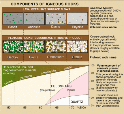
| Chart from the USGS about igneous rocks and their mineral components. Surprisingly, you can find examples of almost every rock on this chart in the Blue Hills. |
The chart above illustrates different igneous rocks and their mineral components. Igneous rocks are rocks formed from magma or lava. If the rock is formed from magma below the surface, it is called an intrusive rock. If the rock is formed above the crust as a result of magma erupting onto the surface as lava, it is an extrusive rock. The Blue Hills are made up of both intrusive and extrusive rocks.
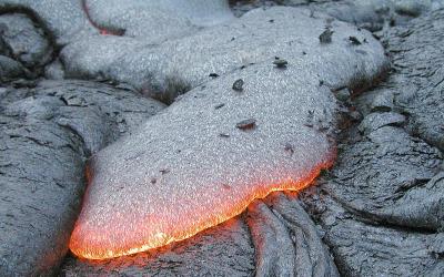
The primary rock composing the Blue Hills is gabbro. Gabbro is a coarse-grained, dark-colored, intrusive igneous rock made up mostly of the minerals plagioclase feldspar and pyroxenes. Gabbro is the intrusive equivalent of the most common extrusive volcanic rock on earth, basalt. Basalt is also present in large quantities in the Blue Hills. Gold Mountain is completely made of basalt, and the large rock outcrops you can see on the north shore of Sinclair Inlet alongside Highway 3 are basalt lava flows. Basalt from the eastern edge of the Blue Hils is mined and used in landscaping and construction purposes. Many of the rock retaining walls you can find around the Kitsap Peninsula were mined from the Blue Hills.
 |
| A typical basalt lava flow. Photo by USGS. |
Following the emplacement of the gabbro and basalt of what would become the Blue Hills, the whole mass of rock was invaded by a swarm of structures known as dikes. Dikes are tabular or sheet-like bodies that intrude into existing rock units vertically or near vertically. When exposed they can look like narrow vertical cracks filled with volcanic or sedimentary material. Two kinds of rocks form the dikes that riddle the Blue Hills. Some of the dikes are andesite, a volcanic rock made up of mostly plagioclase, similar to basalt, but containing some quartz, which is rarely found in basalt. The other type of rock is dacite, another volcanic rock which has an even higher percentage of quartz than andesite (See chart above).
 |
| The final drop of "Gold Creek Cascades" goes over a dike of andesite. |
There are other stories to be told about the geology of the Blue Hills that I left out of this post for the purpose of time and the fact that scrolling for long periods is universally hated. I do plan to stay diligent though and see if I can get the flow going on this blog again. I can't promise multiple posts a week. But hopefully, something between 1-5 posts a month is what I'm shooting for. If there's one thing I love more than geology, it's telling other people about geology. And I've learned a LOT since I last worked on this blog. I think it's time to share some of that. Until next time!
Enjoy your posts. Welcome back!
ReplyDeleteI have heard of the section you mentioned along SR 3 called the "Gorst Horst" a geological feature where the ground fractured and was uplifted via tectonic pressures. Methinks this is how the blue hills formed, with their associated grabens (where the ground sank) much harder to spot. I suspect this horst's grabens are in the lower spots of the Inlet and Hood Canal (making them even harder to spot becuase of erosion and glaciation). I think it makes that outcropping even cooler! And to find out it is gabbro, that's pretty neat.
ReplyDeleteActually, the entirety of the Blue Hills is now treated as one big Horst Block called the "Dewatto Uplift" It's probably related to the Seattle Fault, which skirts the northern Edge of the Blue Hills. The whole area is ridiculously faulted and I'm hoping to write a post about it eventually.
DeleteYou are amazing, Micah!
ReplyDeleteMicah:
ReplyDelete"...the cliffs of basalt towering over highway 16 on the north shore of Sinclair Inlet."
I think you meant highway THREE?
Highway 16 runs on the south shore of Sinclair Inlet. It then terminates at Gorst, where it connects to highway 3.
Suggest you edit. :-)
Greg
Fixed
DeleteI have been trying for years now to find a source for geologic information about the Kitsap Peninsula, thank you for the info and I look forward to more!
ReplyDelete