Showing posts with label Bremerton. Show all posts

Thursday, June 4, 2020

A New Perspective: The Ecologic and Geologic Oasis of Stephenson Canyon, Bremerton.

A sudden wave of nostalgia washed over me as I followed my friend and Kitsap Sun reporter Josh Farley into the depths of Stephenson Canyon. I had last stepped foot here over five years ago, at the very start of the "Kitsap Waterfall Survey" project. 

The canyon was filled with various shades of greens and browns, exploding with the growth of mid-spring. Carpets of sword ferns filled the understory, with large Big-Leaf Maples, Western Red Cedars, and Douglas Firs creating the canopy a hundred feet above our heads. And of course, down at the bottom, Stephenson Creek chattered away, beckoning. 

A "pocket wilderness" inside Bremerton city limits. 

I've learned so much since I first stepped into the canyon. In 2015 I couldn't have cared less what kind of plants and ecology the canyon hosted; I only cared about rocks. Now, I was taking it all in through a new set of skills and experiences. I looked up and around as well as down, remarking the enigma of such a beautiful Pacific Northwest oasis in the middle of a significant city. Craig Romano described it well in Urban Trails: Kitsap when he called it "...a pocket wilderness that feels like it can be deep in the Olympics." 

Of course, it wasn't entirely without flaw. Invasive English Ivy besieged several trees on the rim and down into the canyon, and trash and old city refuse was abundant. A community cleanup effort here would probably breathe some new life into the area, and the city would do well to pay more attention and protect this beautiful piece of borderline old-growth ecosystem. 

Moving on, we descended into the canyon and crossed the creek, moving our eyes away from the canopy and down to the ground. Various cobbles and boulders lined the stream channel, and the footpath traversed some small but textbook stream terraces that probably get a new layer of sand and mud every time the creek floods. 

Our main destination, of course, was "Stephenson Canyon Falls." The little cascade I "discovered" so many years ago. We rounded the corner, and the first words that flashed into my head were, "I'm an idiot." 

Back in 2015, I had no geology education other than a couple basic geology classes, and I hadn't done a whole lot of research on the geology of the bedrock underlying the Kitsap Peninsula. The extent of my knowledge was that most of the bedrock in the area was basalt. So I had assumed that the falls dropped over basalt. I was dead wrong. 

"Stephenson Canyon Falls" with slightly dipping beds of the Blakeley Formation
"Stephenson Canyon Falls" with slightly dipping beds of the Blakeley Formation. The Falls drop over possible sandstone, while the satchel sits on mudstone/siltstone.

"Stephenson Canyon Falls" actually drops over a resistant ledge of the "Blakeley Formation," a much younger rock with a completely different origin than the basaltic rock that makes up the Blue Hills. The area around the falls exposes two types of rock within the Blakeley Formation. The base of the falls is made up of siltstone or mudstone, and the falls themselves drop over what might be a sandstone with larger softball-sized class embedded within it. I have my own interpretations of what this layer might be, but I'm going to hold off on that until a later date after I do more research. 

Downstream of the falls, Stephenson Creek flows over and alongside some of the nicest Glacial Till deposits that I've seen on the Peninsula. Blue Gray concrete-like deposits form shelves and small embankments, peppered with glacial erratics and small potholes drilled during times of flooding or high water.


An exposure of glacial till with a carved pothole at the bottom of Stephenson Canyon. 

After viewing the falls and surrounding geology, it was time for Josh to head back. We made our way downstream again, where we stumbled upon an absolutely titanic Douglas Fir Tree, possibly an old-growth giant from before the first caucasian colonists arrived in Western Washington. It was a sight to behold and was a great symbol that despite the surrounding urban sprawl, Stephenson Canyon is still very much wild. 

Friday, May 15, 2020

Chasing Erratics on the Great (Kitsap) Peninsula.

Yesterday I decided to go on a little adventure and investigate some of the known glacial erratics that I had heard of on the Great (Kitsap) Peninsula, specifically in the Illahee Area.

A glacial erratic is a piece of rock that differs from the size and type of native rock in the area on which it rests. They are carried by glacial ice, often hundreds of miles. Erratics can be as small as pebbles or larger than a building.

Erratics are common on the Great (Kitsap) Peninsula because this area has been subject to half a dozen or more glaciations over the past 2 million years, with the last one ending 16,000 years ago. During these glaciations, a large tongue of ice known as the Puget Lobe advanced south to fill the Puget Lowland as far as Olympia. Over the Great Peninsula, it was probably well over 2,000 feet thick! More than enough to flow entirely over the top of Green Mountain and the rest of the Blue Hills.

The extent of the Puget Lobe of the Canadian ice sheet. Photo courtesy of Washington DNR. 
Since this glacier came from the north, originating in southern Canada, it was plucking pieces of rocks off the mountains there. The rock types found in the Canadian Rockies and coast ranges are much different than those found here on the Great and Olympic Peninsulas, mostly granites and metamorphic rocks. Our hard bedrock here is either igneous rock of the Blue Hills or sedimentary rock of the Blakeley Formation. So if you see a granitic rock somewhere on the Peninsula, whether it be your yard, a beach, or a park, you can assume it's a glacial erratic.

We likely have hundreds if not thousands of significant glacial erratics on our peninsula. Most of them are probably buried beneath the surface, trapped in the thick glacial formations. This point was illustrated to me quite nicely when I was watching a well being drilled near Central Valley, it encountered a glacial erratic along the way down, and suddenly shards and flakes of beautiful granite came flying out!

However, there are some sizable erratics on the surface that you can find. Yesterday I found 3, which are listed below.

  • Ther is a glacial erratic in the Almira Drive parking lot for the Illahee Preserve in East Bremerton. This is a metamorphic rock showing smooth surfaces probably polished by glacial ice as it was transported. 
The Illahee Erratic, with a telephone pole for scale. 
  • There is a large glacial erratic on the east side of Illahee road just as the road begins to drop towards the coast traveling northbound. This is one of the largest erratics I have seen on the Peninsula. And interestingly. It is not granitic or metamorphic, it appears to be a large chunk of basalt, which means it may have been plucked from the Olympic Mountains.
  • On the corner of Trenton Ave and Fernwood Street, in a lucky person's front yard, is a huge glacial erratic of Blue-Gray volcanic rock suspiciously similar looking to the rocks found in the Blue Hills. Perhaps it was plucked off of Green Mountain or one of the surrounding summits? The best viewing for this erratic is in the pullout on the west side of Trenton Ave, please respect the landowner's property by not attempting to go into their yard. 

These are just a few of the many significant erratics that are scattered around the peninsula, as I stumble across more, if they are substantial enough, I will do a write up for them too. I know there are several in North Kitsap, so perhaps I'll go explore up there sometime in the near future. Summer is just around the corner, and geologic adventures are everywhere in Washington State and the Great Peninsula!

Tuesday, April 7, 2020

Drawing the Short Straw: Gorst's 900 A.D Devastation.

Every once in awhile there's a geologic story that just needs to be told.

I have been reading a series of scientific papers about the Seattle Fault. Many people who live on the Great (Kitsap) Peninsula know about the Seattle Fault. This crack in the earth runs east-west from Bellevue to disappear(?) under the glacial deposits west of Lake Symington. The Seattle Fault is capable of producing large earthquakes that shake the entire Puget Sound region, producing tsunamis, triggering landslides, and creating ragged scars across the landscape.

Seattle Fault Line
General map of the Seattle Fault. Map by the Kitsap Sun. 

Bounded on the north by the city of Bremerton, the Sinclair Inlet is one of several bays of the Great Peninsula. Basalt rocks of the Blue Hills meet the shore just west of the shipyard, while the south shore houses the city of Port Orchard. At the west end of Sinclair Inlet, where Gorst Creek kisses saltwater, is its namesake town, Gorst.

Aerial view of Sinclair Inlet looking west. The city of Bremerton lies in the center of the image. Gorst lies at the end of Sinclair Inlet near the top left corner. Image courtesy of Wikipedia. 
One winter day between A.D. 900 and A.D. 930, the entire Puget Lowlands experienced a 7.0-7.5 magnitude earthquake generated by the Seattle Fault, thrusting Gorst upwards by 9-15 feet. Uplift on the floor of Puget Sound spawned a tsunami that struck surrounding beaches, bays, and estuaries, including Sinclair Inlet. A train of waves, perhaps reaching close to 20 feet high, surged into the inlet and crashed ashore at the present-day townsite depositing a layer of sand and mud eight inches thick where cars and trucks are being sold today. According to computer modeling, the wave heights that Gorst endured were some of the largest that struck the Great Peninsula as a result of this event. But that wasn't the final blow.

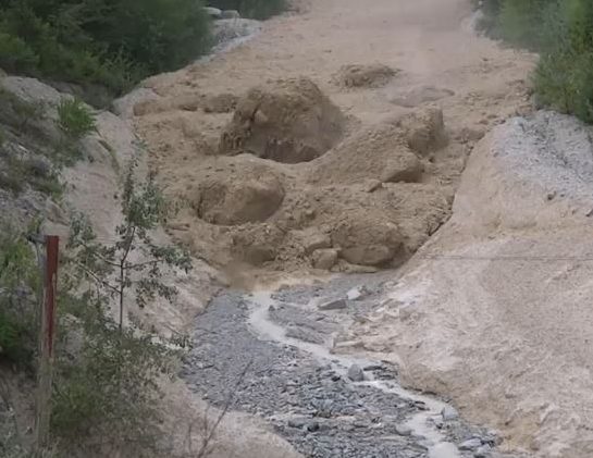
During the earthquake, somewhere near the headwaters of Gorst Creek, a mass of water-saturated glacial debris shook loose, liquified, and began moving downstream as a massive debris flow. The debris flow rolled down the creek, stripping vegetation from the banks and leaving a deposit of sandy material in its wake. It bulldozed over areas that had already been inundated by the tsunami and finally came to rest in Sinclair Inlet, dumping the rest of the material offshore. In some places, such as Otto Jarsted Park, the deposit left behind by the flow is 1.5 feet thick or more.


Illgraben debris flow video - The Landslide Blog - AGU Blogosphere
Debris flow rushing down a valley in the Alps, carrying large boulders. The debris flow that swept down Gorst Creek in A.D. 900-930 may have been similar, but probably did not carry large boulders, as there are none in the resulting deposit. Photo Courtesy of Youtube. 

Before the earthquake, the valley of Gorst Creek was forested with Western Hemlock and Red Cedar. A salt marsh with saltwater grasses marked the transition from Gorst Creek valley into the tidal zone, filled with oysters, mollusks, and clams in thick mud. Following the 900-930 A.D. Seattle Fault earthquake, the tsunami and debris flow had covered the tidal flat and salt marsh with nearly five feet of sand. Gorst Creek was filled with so much material that it likely transformed from a gently meandering stream to a sediment choked braided watercourse for a short period before flushing itself out.

Trash deposits alongside Fountain Creek in Pueblo, where high stormwater events force the stream bed to meander as large sediment volumes accumulate. - COURTESY PUEBLO CITY-COUNTY HEALTH DEPARTMENT
Following the A.D. 900-930 Seattle Fault Earthquake, tsunami, and debris flow, Gorst Creek may have looked similar to this. Courtesy Pueblo City-County Health Department

The sand layers deposited by the tsunami and Gorst debris flow can still be seen today in tidal channels along the bay, leaving stark reminders of the forces that wreaked havoc at the head of Sinclair Inlet 1100 years ago. Similar stories may exist elsewhere, yet to be discovered, but here at Gorst, the sediment record tells a story that presents itself as a clear and present reminder of the hazard that lies beneath our feet. Are you prepared? 

Monday, January 18, 2016

Kitsap Waterfall Survey: "Wright Creek Cascades"

When I first investigated Wright Creek on the western outskirts of Bremerton and surveyed "Wright Creek Falls," I immediately realized that the creek probably had more to offer as it bounced its way down to Sinclair Inlet. I have since visited "Wright Creek Falls" multiple times, and each time got me more and more frustrated at the difficult access downstream of the falls, which appeared to have steep slopes and thick brush. I finally decided that the best way to survey downstream was going to be walking down the stream itself.

I was really hoping that the search would be relatively straight forward, just walk down the creek until I hit a cascade or waterfall. I should have known better. For the next three hours I was in the creek as often as I was out of it. Being out of the creek involved fighting foot-for-foot through Devil's Club, Salmonberry, Swordfern, Salal, and Evergreen Huckleberry. Being in the creek resulted in teeth chattering temperatures, slippery rocks, and hidden pools in the creek which at some points almost sent me up to my waist.

A small unnamed cascade on Wright Creek. Photo by Micah K. 

After passing a few small rapids and interesting little cascades, shin deep in the chilly water, my frustration was mounting. I finally came to a sharp bend in the creek, and as I stepped around it I was immediately met with the thundering roar of crashing water.

"Wright Creek Cascades," Photo by Micah Kipple.
Unfortunately there is a serious foreshortening of the cascades in this photo so they appear smaller than they are in actuality. 
1,100 feet downstream of "Wright Creek Falls," Wright Creek narrows and rockets through a small basalt gorge, this gorge is occupied by "Wright Creek Cascades." The cascades begin immediately after the creek is dammed up behind a small logjam. Composed of three main drops, the cascades total about ten feet in height. Below the cascade the creek appears to calm down, with only one more section of rapids before continuing down towards the Inlet.


Monday, December 21, 2015

Kitsap Waterfall Survey: Tin Mine Creek Revisit 12/13/15

The week prior to December 13, the Kitsap Peninsula had enjoyed a thorough and much needed dousing of steady rain. The creeks predictably swelled in response, and I knew exactly where I wanted to go first. It had been nearly eight months since the last time I visited "Tin Mine Falls" back in March, and it was time to go see the survey's largest waterfall again.

Tin Mine Falls 12/13/15
Photo by Micah K.
Hiking up the dampened GM-1 road, it became quickly apparent there was going to be a lot of water in the creek. Every little side gully and low spot had water in it, and the branches were still dripping. 40 minutes after parking the car, My hiking partner and I finally arrived at the creek. When my friend Spencer and I had first discovered Tin Mine in January 2015, it was full of water, crashing through the basalt canyon. I didn't think it would be possible for the creek to get any more filled, but apparently it is; the swollen spectacle that greeted us on December 13 was nothing short of astounding. The creek was absolutely thundering through the canyon. Arriving at the best spot for viewing I like to call "The Overlook" I came face to face with the entire display.

It became readily apparent to me that we weren't going to be able to make it to the bottom of the largest tier, which requires scrambling up and over the lowest tier of the falls. The amount of water made it nearly impossible, if not downright dangerous. So after watching and photographing "Tin Mine Falls" for a few minutes, we moved towards "Echo Falls," and got another shock.

Usually I access "Echo Falls" by rock hopping across the creek about 50 feet upstream of the falls. This is no longer possible. It appears one of the many windstorms that has slammed the peninsula recently caused 3-4 large pine trees to fall into the creek, shattering and creating a natural dam. The creek has pooled up 3-4 feet deep behind this dam, inundating the once perfect crossing, it's now wade across, or cross a log a little bit more upstream.

Once we successfully crossed to the other side, we scrambled down to "Echo Falls". For the first time I have seen, It was completely full. Words can almost not do it justice.

Echo Falls 12/13/15
Photo by Micah K. 


Monday, November 16, 2015

Kitsap Waterfall Survey: "Heins Creek Falls" Revisit, November 15, 2015

Today I had the pleasure of leading two reporters from the Kitsap Sun newspaper to "Heins Creek Falls." A story by the Kitsap Sun is out to precede my lecture on Thursday.

The day started out almost perfect: overcast skies with almost no wind and a comfortable temperature. I had high hopes as I went through my classes of the day at OC. Unfortunately, Washington had other plans. As soon as I stepped foot outside the building of my last class the sky opened up, and continued raining for the majority of the day. At 2pm I was scheduled to meet up with the reporting team; they arrived right on schedule.

Not wasting any time, we trudged up to the railroad tracks and started toward our destination. We passed by Kitsap Creek, and peered up at "White Train Falls" through the trees; the water was tinted a slight tan color and roared through the canyon. With that much water I doubted I would ever be able to make it up to the fall the way I did before.

"Heins Creek Falls" at high water/flood stage
Finally, after what seemed like a long while of trudging through the ceaseless rainfall, we rounded the bend and the roar of a swollen Heins Creek came to meet us. Scrambling up the sopping almost unrecognizable path to the main tier, my excitement grew exponentially as more and more of the falls came into view; it was absolutely torrential.


Heins Creek was probably two feet higher than normal water level in some places. The main 20 foot tier, which normally is a graceful segmented sliding cascade, was a careening mass of foaming whitewater crashing down the basalt face. In some places, the water hit jutting outcrops of basalt with enough force to create small but powerful rooster tails. When the creek encountered the massive logjam, instead of draining through it, the astounding amount of water was forcing the creek to flow over the logs, plunging down into the large alcove. The final 10 foot cascading section was still recognizable, but a lot more violent as well.

As well as being extremely excited myself, I was pleased to look over and see the reporters with smiles etched on their faces. One remarked "I never knew something like this even existed in Kitsap, this is amazing." Watching waterfalls alone is one thing, but seeing people's reactions to their first sight of them sometimes is even better.

Video of the Falls. 

Thursday, April 30, 2015

Kitsap Waterfall Survey: "Wright Creek Falls"

Wright Creek is a small creek sandwiched between the Blue Hills and the western outskirts of Bremerton. Its headwaters begin in a small series of spring-fed wetlands on peak 730's eastern slope. A few hundred feet after exiting these wetlands, the stream drops into a small canyon just southwest of Bremerton's #3 reservoir. At the head of this canyon is a ten-foot-high basalt headwall covered with a thick layer of green mosses. Wright Creek plunges over this headwall into a shallow plunge pool in the form of a small, but startlingly pretty twelve-foot horsetail waterfall. Upon exiting the pool, the creek steps down several small basalt ledges, before heading into the thick growth of the canyon.

"Wright Creek Falls" during moderate flow.

 About 100 feet to the northeast of "Wright Creek Falls" is a tributary of Wright Creek with its own name; Charlston Creek, which drains a separate set of marshes to the north. Charlston Creek encounters the same basalt outcrop as Wright Creek and careens down a set of bouncing cascades 15 feet high. Only the top few feet of the cascades can be seen because the rest disappears under an impressive logjam that crosses the tributary. The logjam is so compact that soil has formed on the top and forest undergrowth is flourishing, creating a natural tunnel. Because of this feature, I have tentatively named the cascade, "Tunnel Cascade."

The upper portion of "Tunnel Cascade" on Wright Creek's Tributary. Photo by Micah K.
I know of another waterfall or cascade on Wright Creek reportedly large enough that it blocks all fish passage upstream, but unfortunately this fall is likely on private property. However, Wright Creek does have another feature downstream of "Wright Creek Falls," Which is discussed here 

Tuesday, January 20, 2015

Kitsap Waterfall Survey: Lower Dickerson Creek

NOTICE: All boot paths and social trails down to the bottom of the canyon to access "Elegance" and "Divergent" Falls are officially CLOSED with barriers in place.

This closure was a result of multiple rescues being needed in 2018 from falls and injuries in the steep terrain. I talked with the owners of the Tree Farm last night and they said that they plan to open an official trail to these lower falls sometime over the winter. Access to Dickerson Creek Falls over the bridge is still open. PLEASE heed these signs and warnings and do not attempt to go down to the bottom of the canyon until an official trail is built.


The northeast side of the Blue Hills is drained by several creeks that join together to form Chico Creek, which flows into southwestern Dyes Inlet. One of these creeks is named Dickerson Creek. Dickerson Creek is mostly located on the Ueland Tree Farm, a publicly open area that is harvested for resources such as timber and rocks.

About a mile upstream of its confluence with Chico Creek, Dickerson Creek drops over a pair of waterfalls.

At the first falls, Dickerson Creek encounters a shelf of basaltic bedrock and dives 12 feet into a beautiful plunge pool tucked into a rock alcove. A massive nurse log spans the plunge pool, covered in ferns and huckleberries. At high flows, this waterfall can put out an impressive amount of mist and spray for its size. Due to its great beauty, I call this "Elegance Falls."

"Elegance falls" from the base. 2016. Photo by Micah K. 

Following "Elegance Falls," Dickerson Creek flows around a bend and skips down a series of shallow cascades. While pretty, these cascades do not meet the height requirement to make it to my main list of falls.

About 60-80 feet downstream of "Elegance Falls" Dickerson Creek drops over another rock ledge. This fall, significantly larger than "Elegance;" is split completely in two by a large protruding wedge of rock. One half of the creek drops almost the entire 20 feet in a steep sliding cascade. The other side drops two-thirds of that distance in a series of steep cascades, before leaping over the final eight feet in a small horsetail. Because of its bisected appearance, I have suggested the name "Divergent Falls" for this waterfall.

"Divergent Falls" from a precarious viewpoint on the canyon wall. 2016. Photo by Jonas B. 

After "Divergent Falls" the creek quiets down significantly. It meanders through the rest of the canyon calmly, only punctuated by a couple small three-foot cascades. From there, it flows into the lowlands where it eventually meets up with Chico Creek.

Wednesday, January 7, 2015

Kitsap Waterfall Survey: "Stephenson Canyon Falls"

Located in the heart of East Bremerton is a small park encompassing a steep-walled defile carved into the glacial deposits and clay layers near the Port Washington Narrows. This is Stephenson Canyon. flowing through this canyon is small but quaint Stephenson Creek, which flows year round. Looking at topographic maps and google terrain imagery. I entertained the idea that somewhere along this canyon there might be a waterfall. I wasn't expecting a titanic 50-60 footer producing a jet like roar, but I entertained the possibility of maybe a small one ten to twenty feet tall or a pretty cascade, and my curiosity drove me on.

Shaded relief map from Google Maps showing the location of Stephenson Canyon in East Bremerton. 
One afternoon I drove down to the canyon, parked at the trailhead and began walking upstream along the creek. The gently rounded boulders and vegetated slopes soon gave way to hard blue clay shelves and carved notches. Once or twice I passed by some very tiny cascades maybe one to two feet high tumbling over more resistant clay outcrops. And soon the clay gave way completely to slippery bedrock, which suddenly rose out of the creek producing a delightful three-foot-tall cascade.

Three Foot Cascade. Photo by Micah Kipple
Pushing on around a couple more bends, the sound of hissing water made me look up, and there leaping off of a small ledge of rounded rock into a green-blue catch basin was a five-foot waterfall. A smile crossed my face as I stepped onto a nearby ledge on the creekside to get a better look. Then I saw the second tier. Almost hidden by a sharp turn in the creek, this tier slid down the shallow face of another basalt ledge another five to six feet, bringing this waterfall's total height to about 10 feet. I was ecstatic, while there were numerous signs I wasn't the first one here. I was still pleased I had found a waterfall, regardless of how small it was (Ok, if it was under four feet it would be pushing it), and smack in the middle of Bremerton no less.

The lower horsetail tier of Stephenson Canyon Falls. Photo by Micah Kipple
While these falls are beautiful, getting to them is somewhat of a chore, and they aren't as pretty as they could be. I'm going to make an effort to pick up trash while I'm there in the park, and I need to find a way to put this on the City of Bremerton's radar so maybe there can be an official volunteer effort to clear the area around the falls. That would be very nice indeed and would make this a destination to keep going back to.

A close up of the lower tier. Photo by Micah Kipple.

Both tiers of the falls. Photo by Micah Kipple.