Showing posts with label Kitsap Peninsula. Show all posts

Friday, May 15, 2020

Chasing Erratics on the Great (Kitsap) Peninsula.

Yesterday I decided to go on a little adventure and investigate some of the known glacial erratics that I had heard of on the Great (Kitsap) Peninsula, specifically in the Illahee Area.

A glacial erratic is a piece of rock that differs from the size and type of native rock in the area on which it rests. They are carried by glacial ice, often hundreds of miles. Erratics can be as small as pebbles or larger than a building.

Erratics are common on the Great (Kitsap) Peninsula because this area has been subject to half a dozen or more glaciations over the past 2 million years, with the last one ending 16,000 years ago. During these glaciations, a large tongue of ice known as the Puget Lobe advanced south to fill the Puget Lowland as far as Olympia. Over the Great Peninsula, it was probably well over 2,000 feet thick! More than enough to flow entirely over the top of Green Mountain and the rest of the Blue Hills.

The extent of the Puget Lobe of the Canadian ice sheet. Photo courtesy of Washington DNR. 
Since this glacier came from the north, originating in southern Canada, it was plucking pieces of rocks off the mountains there. The rock types found in the Canadian Rockies and coast ranges are much different than those found here on the Great and Olympic Peninsulas, mostly granites and metamorphic rocks. Our hard bedrock here is either igneous rock of the Blue Hills or sedimentary rock of the Blakeley Formation. So if you see a granitic rock somewhere on the Peninsula, whether it be your yard, a beach, or a park, you can assume it's a glacial erratic.

We likely have hundreds if not thousands of significant glacial erratics on our peninsula. Most of them are probably buried beneath the surface, trapped in the thick glacial formations. This point was illustrated to me quite nicely when I was watching a well being drilled near Central Valley, it encountered a glacial erratic along the way down, and suddenly shards and flakes of beautiful granite came flying out!

However, there are some sizable erratics on the surface that you can find. Yesterday I found 3, which are listed below.

  • Ther is a glacial erratic in the Almira Drive parking lot for the Illahee Preserve in East Bremerton. This is a metamorphic rock showing smooth surfaces probably polished by glacial ice as it was transported. 
The Illahee Erratic, with a telephone pole for scale. 
  • There is a large glacial erratic on the east side of Illahee road just as the road begins to drop towards the coast traveling northbound. This is one of the largest erratics I have seen on the Peninsula. And interestingly. It is not granitic or metamorphic, it appears to be a large chunk of basalt, which means it may have been plucked from the Olympic Mountains.
  • On the corner of Trenton Ave and Fernwood Street, in a lucky person's front yard, is a huge glacial erratic of Blue-Gray volcanic rock suspiciously similar looking to the rocks found in the Blue Hills. Perhaps it was plucked off of Green Mountain or one of the surrounding summits? The best viewing for this erratic is in the pullout on the west side of Trenton Ave, please respect the landowner's property by not attempting to go into their yard. 

These are just a few of the many significant erratics that are scattered around the peninsula, as I stumble across more, if they are substantial enough, I will do a write up for them too. I know there are several in North Kitsap, so perhaps I'll go explore up there sometime in the near future. Summer is just around the corner, and geologic adventures are everywhere in Washington State and the Great Peninsula!

Tuesday, April 7, 2020

Drawing the Short Straw: Gorst's 900 A.D Devastation.

Every once in awhile there's a geologic story that just needs to be told.

I have been reading a series of scientific papers about the Seattle Fault. Many people who live on the Great (Kitsap) Peninsula know about the Seattle Fault. This crack in the earth runs east-west from Bellevue to disappear(?) under the glacial deposits west of Lake Symington. The Seattle Fault is capable of producing large earthquakes that shake the entire Puget Sound region, producing tsunamis, triggering landslides, and creating ragged scars across the landscape.

Seattle Fault Line
General map of the Seattle Fault. Map by the Kitsap Sun. 

Bounded on the north by the city of Bremerton, the Sinclair Inlet is one of several bays of the Great Peninsula. Basalt rocks of the Blue Hills meet the shore just west of the shipyard, while the south shore houses the city of Port Orchard. At the west end of Sinclair Inlet, where Gorst Creek kisses saltwater, is its namesake town, Gorst.

Aerial view of Sinclair Inlet looking west. The city of Bremerton lies in the center of the image. Gorst lies at the end of Sinclair Inlet near the top left corner. Image courtesy of Wikipedia. 
One winter day between A.D. 900 and A.D. 930, the entire Puget Lowlands experienced a 7.0-7.5 magnitude earthquake generated by the Seattle Fault, thrusting Gorst upwards by 9-15 feet. Uplift on the floor of Puget Sound spawned a tsunami that struck surrounding beaches, bays, and estuaries, including Sinclair Inlet. A train of waves, perhaps reaching close to 20 feet high, surged into the inlet and crashed ashore at the present-day townsite depositing a layer of sand and mud eight inches thick where cars and trucks are being sold today. According to computer modeling, the wave heights that Gorst endured were some of the largest that struck the Great Peninsula as a result of this event. But that wasn't the final blow.

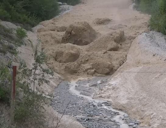
During the earthquake, somewhere near the headwaters of Gorst Creek, a mass of water-saturated glacial debris shook loose, liquified, and began moving downstream as a massive debris flow. The debris flow rolled down the creek, stripping vegetation from the banks and leaving a deposit of sandy material in its wake. It bulldozed over areas that had already been inundated by the tsunami and finally came to rest in Sinclair Inlet, dumping the rest of the material offshore. In some places, such as Otto Jarsted Park, the deposit left behind by the flow is 1.5 feet thick or more.


Illgraben debris flow video - The Landslide Blog - AGU Blogosphere
Debris flow rushing down a valley in the Alps, carrying large boulders. The debris flow that swept down Gorst Creek in A.D. 900-930 may have been similar, but probably did not carry large boulders, as there are none in the resulting deposit. Photo Courtesy of Youtube. 

Before the earthquake, the valley of Gorst Creek was forested with Western Hemlock and Red Cedar. A salt marsh with saltwater grasses marked the transition from Gorst Creek valley into the tidal zone, filled with oysters, mollusks, and clams in thick mud. Following the 900-930 A.D. Seattle Fault earthquake, the tsunami and debris flow had covered the tidal flat and salt marsh with nearly five feet of sand. Gorst Creek was filled with so much material that it likely transformed from a gently meandering stream to a sediment choked braided watercourse for a short period before flushing itself out.

Trash deposits alongside Fountain Creek in Pueblo, where high stormwater events force the stream bed to meander as large sediment volumes accumulate. - COURTESY PUEBLO CITY-COUNTY HEALTH DEPARTMENT
Following the A.D. 900-930 Seattle Fault Earthquake, tsunami, and debris flow, Gorst Creek may have looked similar to this. Courtesy Pueblo City-County Health Department

The sand layers deposited by the tsunami and Gorst debris flow can still be seen today in tidal channels along the bay, leaving stark reminders of the forces that wreaked havoc at the head of Sinclair Inlet 1100 years ago. Similar stories may exist elsewhere, yet to be discovered, but here at Gorst, the sediment record tells a story that presents itself as a clear and present reminder of the hazard that lies beneath our feet. Are you prepared?