Showing posts with label Basalt. Show all posts

Wednesday, April 1, 2020

Kitsap County Geology: Green Mountain, Gold Mountain, and the Blue Hills.


I'm back. And no foolin'. 

The volcanic plateau of Yellowstone National Park that I call home is closed, set to reopen in the future at some as yet undecided date due to the pandemic sweeping the globe. I'm currently in Kitsap for the time being, socially isolating and eagerly awaiting any news. So during this lull, I got out the technological feather duster and opened this blog up after a...*quick mental math*... two-year absence. My sincerest apologies to devoted readers out there. 

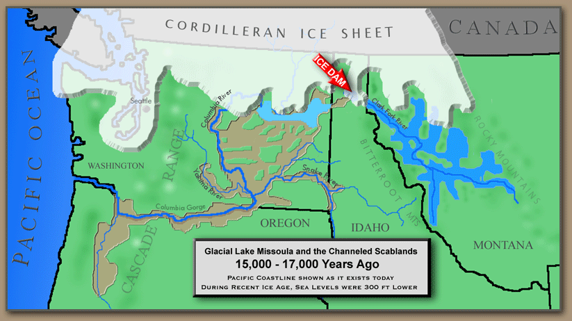
Everyone in Kitsap County knows about Green Mountain, our forested little peak rising to an altitude of 1,710 feet, the second-highest peak on the Kitsap Peninsula. Gold Mountain to the south beats it out by 50 feet, reaching 1,761 feet. Green and Gold Mountains are the two highest summits in a cluster of hills referred to collectively as the Blue Hills. The Blue Hills is an official name accepted by the United States Geologic Survey, I would love for it to become common usage. Wishful thinking? probably, but you heard it here first!

Terrain map of the Blue Hills. on the Kitsap Peninsula. The city of Bremerton lies on the right side of the image. Kitsap Lake in the right-center. 
The Blue Hills emerge like the tip of a rocky iceberg from the center of the Kitsap Peninsula in a sea of glacial deposits. The glacial deposits have their own story, but that's a tale for another time. What are the Blue Hills made out of anyways? 

Components of Igneous Rocks
 (Click image to view full size.)
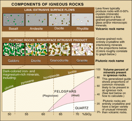
Chart from the USGS about igneous rocks and their mineral components. Surprisingly, you can find examples of almost every rock on this chart in the Blue Hills. 

The chart above illustrates different igneous rocks and their mineral components. Igneous rocks are rocks formed from magma or lava. If the rock is formed from magma below the surface, it is called an intrusive rock. If the rock is formed above the crust as a result of magma erupting onto the surface as lava, it is an extrusive rock. The Blue Hills are made up of both intrusive and extrusive rocks.

The primary rock composing the Blue Hills is gabbro. Gabbro is a coarse-grained, dark-colored, intrusive igneous rock made up mostly of the minerals plagioclase feldspar and pyroxenes. Gabbro is the intrusive equivalent of the most common extrusive volcanic rock on earth, basalt. Basalt is also present in large quantities in the Blue Hills. Gold Mountain is completely made of basalt, and the large rock outcrops you can see on the north shore of Sinclair Inlet alongside Highway 3 are basalt lava flows. Basalt from the eastern edge of the Blue Hils is mined and used in landscaping and construction purposes. Many of the rock retaining walls you can find around the Kitsap Peninsula were mined from the Blue Hills.

Hot basalt lava flowing over the surface of a cooled basalt lava flow.
 (Click image to view full size.)
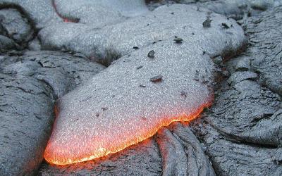
A typical basalt lava flow. Photo by USGS. 

Following the emplacement of the gabbro and basalt of what would become the Blue Hills, the whole mass of rock was invaded by a swarm of structures known as dikes. Dikes are tabular or sheet-like bodies that intrude into existing rock units vertically or near vertically. When exposed they can look like narrow vertical cracks filled with volcanic or sedimentary material. Two kinds of rocks form the dikes that riddle the Blue Hills. Some of the dikes are andesite, a volcanic rock made up of mostly plagioclase, similar to basalt, but containing some quartz, which is rarely found in basalt. The other type of rock is dacite, another volcanic rock which has an even higher percentage of quartz than andesite (See chart above).

The final drop of "Gold Creek Cascades" goes over a dike of andesite. 
So, where can you see these rocks? Unfortunately, if there's one thing that Kitsap geology isn't, it's being easy to see. Right square in the center of the Pacific Northwest, our lush vegetation and vibrant growth hides most of the rocks from our sight. I already mentioned the most easily visible outcrop of rock in the county, the cliffs of basalt towering over highway 16 on the north shore of Sinclair Inlet. Aside from that, there are exposures of gabbro and basalt on the way up to the summit of green mountain, with the main viewing area (currently closed as of this writing) being built on the edge of a large basalt cliff. If you know the location of "school rock/turtle rock/eagle rock" on the south flank of Green Mountain, that is composed of gabbro. And there are a couple blink-and-you-miss-it outcrops of rock along the south side of Holly Road as it skirts the base of Peak 1291.

There are other stories to be told about the geology of the Blue Hills that I left out of this post for the purpose of time and the fact that scrolling for long periods is universally hated. I do plan to stay diligent though and see if I can get the flow going on this blog again. I can't promise multiple posts a week. But hopefully, something between 1-5 posts a month is what I'm shooting for. If there's one thing I love more than geology, it's telling other people about geology. And I've learned a LOT since I last worked on this blog. I think it's time to share some of that. Until next time!

Monday, February 5, 2018

Kitsap Waterfall Survey: "Lower Lost Creek Cascades"

Well over a year since I've last surveyed a waterfall on the Kitsap Peninsula, this was a nice return to form. Several months ago, a friend of mine mentioned to me the existence of a small cascading type waterfall on Lost Creek within publicly accessible land. With me being busy at CWU, it was put on the back burner at the time. Not anymore, This past weekend (2/4/2018) I joined my friend, his son, and their dog and set out to document and photograph this cascade with my own eyes.

Our waterfalling dog companion, Delilah.
A half-mile after it's opening fanfare, Lost Creek encounters another outcrop of Siletzia bedrock which underlies much of the Kitsap Peninsula. The canyon walls and creek bed become lined with a gorgeous blue-green-gray basaltic rock. After tripping over a small rapid in the shadow of a massive fir stump, the creek flows around a bend and slides over a ten-foot drop into a beautifully secluded alcove with a surprisingly deep plunge pool.

The initial 10-foot drop of "Lower Lost Creek Cascades" 
Immediately after this drop, the creek narrows from 10 feet wide to less than 3 feet and careens through a narrow slot cut into the rock, dropping an additional 4 feet in the process. The force of the water tearing through this slot has drilled large circular potholes into the bedrock, making interesting shapes and formations.

Lost Creek tearing through the small defile, with several large potholes in the foreground
Immediately after the main slot, the creek funnels through another bottleneck in the rock in a slide 3 feet high slamming into a jutting rock, taking a 90-degree turn to the left and bouncing over a couple small drops, before leaping over a messy 5-foot rock face. This final drop ends in a rocky alcove similar to the large one upstream. Shortly downstream, "Lower Lost Creek Cascades" terminates in a final small 3-foot slide, bringing the total height to ~25 feet.

The bedrock lining the creekbed. 
The geology of the canyon here is both fascinating and stunning. The underlying grey-blue gabbro rock sets the tone, peppered with red-brown pieces of basalt, and cut with white veins of quartz and calcite. In quieter pools and gravel bars, occasional light colored granite clasts can be found from the overlying glacial debris mantling the entire peninsula. At least at one spot within the cascade, I found evidence for faulting and the intrusion of volcanic andesite dikes 50 million years ago. I plan to write posts on both those geologic stories in the near future.


Tuesday, November 8, 2016

Kitsap Waterfall Survey: Upper Dickerson Creek.

Thus far, I have written about four of Dickerson Creek's waterfalls: "Elegance," "Divergence," "Dickerson Creek", and "Beaver Dam Lake Falls." Finally, I'm crossing off the final two waterfalls. Both are located on upper Dickerson Creek before it enters Beaver Dam Lake.

Dickerson Creek spawns in a marshy lake in southwestern Ueland Tree Farm. There are several lakes like this on the farm, resting in valleys gouged out by the glaciers that covered the Kitsap Peninsula 17,000 years ago. After it exits the lake, the first half-mile of Dickerson Creek is calm, flowing through the dense second-growth forest. This quiescence is cut short as the creek encounters the first rock layer on its tumultuous journey to Chico Creek.

"Cedar Gorge Falls" The first waterfall on Dickerson Creek. Photo by Micah K.
What the first waterfall on Dickerson Creek lacks in height, it makes up for in character. Here the creek intersects a basalt ledge and dives ten feet into a shaded, dark pool carved into the head of a steep-sided gorge. Several young cedar trees overhang this pool, adding to the shaded environment. For the presence of these trees and the overall location of this fall, I have named it "Cedar Gorge Falls."

"Upper Dickerson Falls" upper tier. Photo by Micah K. 

Flowing for another 60-70 feet and around a slight corner, the creek exits the gorge and drops over another, more striking fall. This is "Upper Dickerson Falls" This waterfall is composed of two tiers totaling about 30 feet in height. The first tier begins as a shallow cascade hissing over orange-red colored basalt which rapidly steepens into a final slide into a shallow basin. In low to medium water levels, only a small portion of the basalt face has water flowing over it, but I imagine in the height of winter or after a heavy rain, the entire shelf is one roaring mass of violent whitewater.

Between the two tiers is a section of level creekbed with a bottom of rounded stones. These stones range in composition from the basalt of the falls to pink-tan granites transported onto the Kitsap Peninsula from the northern cascades by the ice-age glaciers.

The second tier would be as gorgeous as the first, if it weren't for the two massive logs that have fallen across it, effectively blocking half from view. Despite this eyesore, the color of the bedrock is a mesmerizing dark blue-purple. At the base of the falls is another large piece of bedrock checkerboarded red and blue with white mineral veins crisscrossing the surface. Not only is this one of the most visually pleasing falls in the county, but it's also one of the best geologic outcrops Kitsap has to offer too.

"Upper Dickerson Creek Falls" bottom tier, Photo by Micah K.

Monday, October 31, 2016

Kitsap Waterfall Survey: Changing scenery at "Heins Creek Falls"

The upper tier of "Heins Creek Falls" with scale.
Photo by Micah K. 
On Sunday 10/30/2016 I visited one of my favorite falls in the area, "Heins Creek Falls" and was delighted to find that the recent rains have reinvigorated the creek and the falls were roaring with jubilee.

Everything about the first tier appeared to be in order, so I moved down to the second tier, which I haven't seen up close since the last time I first discovered the falls over a year and a half ago. What I found surprised me greatly.

If you read my original write up about this falls, you will find that I describe the second drop of this falls as slipping through a large logjam which is damming up the creek before it plunges 20 feet into a crevice. Well....things have changed a little bit.

When I arrived at the second tier, it had changed it's appearance drastically. The logjam has apparently settled even more since my last visit, and is beginning to block water flow from above. As a result, nearly half the volume of the creek is now plunging over the cliff over 30 feet from where it originally was. A swath of hillside that used to be covered in ferns, leaves, and soil is now bare basalt with roaring whitewater tumbling over it. The resulting display is absolutely spectacular.

The second tier of "Heins Creek Falls." Photo by Micah K. 


Sunday, May 8, 2016

Frenchman Coulee and Echo Basin, Overflowing the Bathtub

Time to play catch up It's a been a while.

Lets rewind the clocks back to 15,000 years ago. Our stage curtain opens with the northern hemisphere gripped in the frigid clutches of an ice age. Canada is completely smothered, the Puget Sound region is filled to the brim, and several tongues of ice extend down through north-central Washington, northern Idaho, and Montana. One of these lobes has blocked up one of western Montana's largest rivers, the Clark Fork. The pooling lake behind this icy blockade, named Glacial Lake Missoula by modern day geologists, has risen over 900 feet in some valleys. The location of downtown Missoula, Montana is now resting at the bottom of a body of water dwarfing any lake in the western US today.

Map showing the location of Glacial Lake Missoula and the path of the ice age floods. 
But then, something happened, a catastrophic event that rearranged the face of eastern Washington forever. The ice dam holding back Glacial Lake Missoula breached. A massive wall of water, filled with icebergs, boulders, trees, tore through the narrow river valleys of the Idaho panhandle and plowed into another huge glacial lake resting over what is now Spokane and extending northwest. But even this huge glacial lake was not enough to halt the flow of this sudden rush of water, the second lake also breached and the floodwaters made their way to the Columbia River the fastest way they could, through the Columbia River Basalts.

The Columbia River Basalts, were formed 18-15 Million Years ago when the Yellowstone Hot Spot began it's chain of cataclysmic explosive eruptions in southwestern Idaho. The basalt flows covered 40% of Washington State in a flat plateau up to 3 miles thick. But as sizable as this blanket of rock was, it hardly slowed the raging water down.

Artist's rendition of what the floods may have looked like as they flowed through the Grand Coulee. 

The incredible force of the gargantuan torrent ripped into the basalt rock with vengeance, scouring huge, square-shaped canyons, or "Coulees", into the bedrock as it flowed towards the Columbia. However, at a certain point during its journey, it paused. One branch of the flood encountered the basin of an ancient lake, a geologic bathtub perched high above the eastern shore of the Columbia. The water was temporarily halted as it filled the lake basin, but the volume was too much. Eventually the flood spilled over the western rim of the bathtub.  Huge waterfalls, unlike anything the world has ever seen today, crashed over cliffs hundreds of feet into the waiting maw of the Columbia's canyon. As the volume of water going over the falls increased, the waterfalls migrated backwards, eating their way through weak layers of columnar basalt flows, picking away individual columns like straws; Frenchman Coulee was being born. At the same time slightly further to the south, Echo Basin, a huge amphitheater carved into the same lava flow as Frenchman Coulee, was also forming. Eventually, the headwalls of these spectacular basins, now used as a playground for hikers and rock climbers, and prime rattlesnake habitat, were worn back to the point where they remain today.

Looking out over Echo Basin on the edge of the Columbia River canyon (Background). Note the prominent Basalt Columns on the right side of the image. Photo by Micah K. 

Tuesday, April 5, 2016

Geomorphology of the northern Thorp Region

The small hamlet of Thorp, Washington, lies about 14 minutes to the west of Ellensburg as the cwu geology van drives. It is located in the Yakima River Valley, the namesake of which meanders it's way north of Thorp slowly making it's way southeast. 

Today I ventured out on a field trip with my Geomorphology class to observe some of the Geomorphological features of the area. What is Geomorphology? Just break it up! Geo=Earth, Morph=Change, and Ology=To Study. So putting it all together, it's the study of landforms created through geologic processes. 

The first feature we observed was the most interesting to me personally. Almost 2.8 miles due north and a little west of Exit 101 on Interstate-90, is a large hillside comprising of ancient Yakima River Sediments. At this point, 1.5 to 5 thousand years ago, the hillside failed. Possibly driven by weak clays or saturated soils, a massive rotational-slump type landslide broke loose. The resulting earth flow at the foot of the slide shoved the Yakima River south by several hundred feet. 

Looking across the large landslide north of Thorp. Photo by Micah K. 

From an overlook at the western edge of the landslide, my Geomorphology class looked across this landslide. The displaced material had taken on a hummocky appearance, with the blocks tilted slightly towards the failure headwall. The size of this thing was boggling, even while small in comparison with the landslide that, for example, decapitated Mount Saint Helens in 1980 with catastrophic results. Even the several houses that were built on top of the landslide deposits seemed small in comparison. It was truly amazing.

Northwest of Thorp, Interstate 90, climbs up another large slope and across the wide, rolling expanse of basalt boulders and sagebrush known as the Thorp Prairie. It's strangely empty up on this expanse, only being occupied by several old and dilapidated windmills, and crisscrossed by irrigation canals. The reason for this emptiness being most in part for it's geology. Thorp Prarie sits on a massive terminal moraine formed many thousands of years ago when a large glacier flowed down the Yakima River Valley. The heart of this moraine is filled with rocky glacial garbage, scraped out from the mountains and dumped here as the glacier retreated, too rocky to farm on, and not very suitable for irrigation, this, it has remained relatively untouched. 

As the Yakima River carves it's way through this moraine to the north, over thousands of years it has created several large flood terraces visible on the flank of the moraine and elsewhere in the valley walls. These large flat expanses are sometimes built directly on top of Columbia River Basalt, which is exposed in the deepest parts of the canyon by the river. And as luck would have it, I'm going to see a important portion of the Columbia River Basalt tomorrow. So...to be continued......

Erosional Remnant of the Columbia River Basalt. Photo by Micah K.