Showing posts with label Green Mountain. Show all posts

Wednesday, April 1, 2020

Kitsap County Geology: Green Mountain, Gold Mountain, and the Blue Hills.


I'm back. And no foolin'. 

The volcanic plateau of Yellowstone National Park that I call home is closed, set to reopen in the future at some as yet undecided date due to the pandemic sweeping the globe. I'm currently in Kitsap for the time being, socially isolating and eagerly awaiting any news. So during this lull, I got out the technological feather duster and opened this blog up after a...*quick mental math*... two-year absence. My sincerest apologies to devoted readers out there. 

Everyone in Kitsap County knows about Green Mountain, our forested little peak rising to an altitude of 1,710 feet, the second-highest peak on the Kitsap Peninsula. Gold Mountain to the south beats it out by 50 feet, reaching 1,761 feet. Green and Gold Mountains are the two highest summits in a cluster of hills referred to collectively as the Blue Hills. The Blue Hills is an official name accepted by the United States Geologic Survey, I would love for it to become common usage. Wishful thinking? probably, but you heard it here first!

Terrain map of the Blue Hills. on the Kitsap Peninsula. The city of Bremerton lies on the right side of the image. Kitsap Lake in the right-center. 
The Blue Hills emerge like the tip of a rocky iceberg from the center of the Kitsap Peninsula in a sea of glacial deposits. The glacial deposits have their own story, but that's a tale for another time. What are the Blue Hills made out of anyways? 
Components of Igneous Rocks
 (Click image to view full size.)
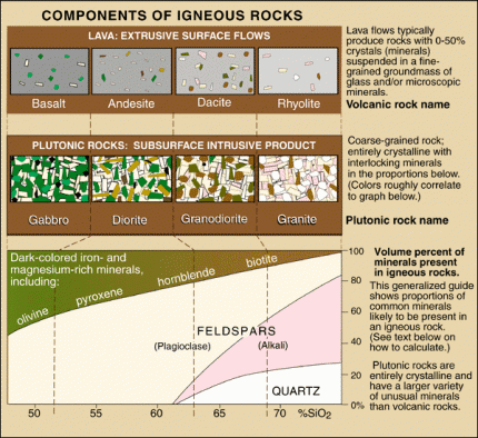
Chart from the USGS about igneous rocks and their mineral components. Surprisingly, you can find examples of almost every rock on this chart in the Blue Hills. 

The chart above illustrates different igneous rocks and their mineral components. Igneous rocks are rocks formed from magma or lava. If the rock is formed from magma below the surface, it is called an intrusive rock. If the rock is formed above the crust as a result of magma erupting onto the surface as lava, it is an extrusive rock. The Blue Hills are made up of both intrusive and extrusive rocks.

The primary rock composing the Blue Hills is gabbro. Gabbro is a coarse-grained, dark-colored, intrusive igneous rock made up mostly of the minerals plagioclase feldspar and pyroxenes. Gabbro is the intrusive equivalent of the most common extrusive volcanic rock on earth, basalt. Basalt is also present in large quantities in the Blue Hills. Gold Mountain is completely made of basalt, and the large rock outcrops you can see on the north shore of Sinclair Inlet alongside Highway 3 are basalt lava flows. Basalt from the eastern edge of the Blue Hils is mined and used in landscaping and construction purposes. Many of the rock retaining walls you can find around the Kitsap Peninsula were mined from the Blue Hills.
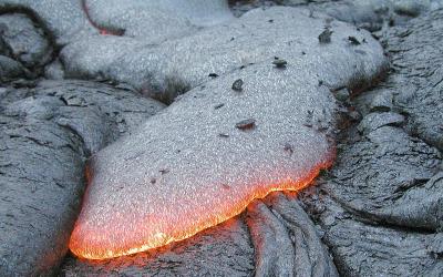
Hot basalt lava flowing over the surface of a cooled basalt lava flow.
 (Click image to view full size.)
A typical basalt lava flow. Photo by USGS. 

Following the emplacement of the gabbro and basalt of what would become the Blue Hills, the whole mass of rock was invaded by a swarm of structures known as dikes. Dikes are tabular or sheet-like bodies that intrude into existing rock units vertically or near vertically. When exposed they can look like narrow vertical cracks filled with volcanic or sedimentary material. Two kinds of rocks form the dikes that riddle the Blue Hills. Some of the dikes are andesite, a volcanic rock made up of mostly plagioclase, similar to basalt, but containing some quartz, which is rarely found in basalt. The other type of rock is dacite, another volcanic rock which has an even higher percentage of quartz than andesite (See chart above).

The final drop of "Gold Creek Cascades" goes over a dike of andesite. 
So, where can you see these rocks? Unfortunately, if there's one thing that Kitsap geology isn't, it's being easy to see. Right square in the center of the Pacific Northwest, our lush vegetation and vibrant growth hides most of the rocks from our sight. I already mentioned the most easily visible outcrop of rock in the county, the cliffs of basalt towering over highway 16 on the north shore of Sinclair Inlet. Aside from that, there are exposures of gabbro and basalt on the way up to the summit of green mountain, with the main viewing area (currently closed as of this writing) being built on the edge of a large basalt cliff. If you know the location of "school rock/turtle rock/eagle rock" on the south flank of Green Mountain, that is composed of gabbro. And there are a couple blink-and-you-miss-it outcrops of rock along the south side of Holly Road as it skirts the base of Peak 1291.

There are other stories to be told about the geology of the Blue Hills that I left out of this post for the purpose of time and the fact that scrolling for long periods is universally hated. I do plan to stay diligent though and see if I can get the flow going on this blog again. I can't promise multiple posts a week. But hopefully, something between 1-5 posts a month is what I'm shooting for. If there's one thing I love more than geology, it's telling other people about geology. And I've learned a LOT since I last worked on this blog. I think it's time to share some of that. Until next time!

Saturday, January 30, 2016

Kitsap Waterfall Survey: "Claire Falls"

There are multiple places in Washington State where a very respectable and sometimes spectacular waterfall is nearly eclipsed by an even bigger one nearby. It just so happens that there is one of these situations in Kitsap County. It turns out, "Tin Mine Falls" has a much smaller sibling.

During the wet times of the year (fall/winter/spring), small ponds and rain runoff give rise to a quaint little brook along the mountainside between Tin Mine Creek and a smaller tributary to the west. This tiny stream, nearly imperceptible on topographic maps and imagery, babbles through the forest, running generally northeast, straight towards Tin Mine Creek's canyon. Just downstream of "Tin Mine Falls," the brook intersects the near-vertical basalt canyon wall of and promptly dives over it. The resulting 40+ foot ribbon-like waterfall is startlingly beautiful, and would be commanding the attention of everything around it if it wasn't dwarfed by its colossal neighbor.

The lower section of "Claire Falls" as it's namesake looks on. Photo by Micah K. 
It is likely that this fall runs dry by July or August, but when it is flowing, it is a beautiful sight indeed, and so I have it included in my survey. After I first saw it in January 2015, I was trying to think of a name for it for months. One day a good friend of mine visited, and I took her to see "Tin Mine Falls." While she enjoyed "Tin Mine Falls" immensely, she also took an extreme liking to this little ephemeral fall. Because of this, I decided to name the fall after her.  

Monday, December 21, 2015

Kitsap Waterfall Survey: Tin Mine Creek Revisit 12/13/15

The week prior to December 13, the Kitsap Peninsula had enjoyed a thorough and much needed dousing of steady rain. The creeks predictably swelled in response, and I knew exactly where I wanted to go first. It had been nearly eight months since the last time I visited "Tin Mine Falls" back in March, and it was time to go see the survey's largest waterfall again.

Tin Mine Falls 12/13/15
Photo by Micah K.
Hiking up the dampened GM-1 road, it became quickly apparent there was going to be a lot of water in the creek. Every little side gully and low spot had water in it, and the branches were still dripping. 40 minutes after parking the car, My hiking partner and I finally arrived at the creek. When my friend Spencer and I had first discovered Tin Mine in January 2015, it was full of water, crashing through the basalt canyon. I didn't think it would be possible for the creek to get any more filled, but apparently it is; the swollen spectacle that greeted us on December 13 was nothing short of astounding. The creek was absolutely thundering through the canyon. Arriving at the best spot for viewing I like to call "The Overlook" I came face to face with the entire display.

It became readily apparent to me that we weren't going to be able to make it to the bottom of the largest tier, which requires scrambling up and over the lowest tier of the falls. The amount of water made it nearly impossible, if not downright dangerous. So after watching and photographing "Tin Mine Falls" for a few minutes, we moved towards "Echo Falls," and got another shock.

Usually I access "Echo Falls" by rock hopping across the creek about 50 feet upstream of the falls. This is no longer possible. It appears one of the many windstorms that has slammed the peninsula recently caused 3-4 large pine trees to fall into the creek, shattering and creating a natural dam. The creek has pooled up 3-4 feet deep behind this dam, inundating the once perfect crossing, it's now wade across, or cross a log a little bit more upstream.

Once we successfully crossed to the other side, we scrambled down to "Echo Falls". For the first time I have seen, It was completely full. Words can almost not do it justice.

Echo Falls 12/13/15
Photo by Micah K. 


Wednesday, November 25, 2015

Kitsap Waterfall Survey: "Contact Cascades"-My 20th waterfall!

Following my lecture at the Norm Dicks Government Building in Bremerton, one of the audience members came to me and told me of a waterfall on the Beaver Pond Trail within the Green Mountain State Forest. Their description seemed to indicate something small, but they insisted it was over bedrock, and so I decided to investigate.

As the wind howled through the trees and branches of various sizes fell all around, I hiked up the side of Green Mountain until I reached the Beaver Pond Trail. Within a few hundred feet, the trail crosses over Grata Creek, a stream running down the northwest side of Green Mountain. Grata Creek has long been on my radar, as it drops rather rapidly from high up on the mountain slopes before emptying into Tahuya Lake.

Lidar imagery map of Grata Creek. 
Even with these suspicions, I realized that most of the creek was bounded by private property, and so any falls and cascades would be inaccessible to me. Grata Creek originates on a spring fed lake tucked at the head of a forested valley at about 950 feet. The creek flows from this lake and bypasses another lake. It is after this second lake the creek steepens significantly and the private property begins. This is is the only place I thought falls would occur. I was wrong

Shortly after exiting its source lake Grata Creek meanders through some open pine forest, then less than a quarter mile later, it passes underneath the Beaver Pond Trail bridge, and immediately skips over a series of wonderful cascades over 20 feet in height, right next to the trail and very easily visible.

Bridge over Grata Creek
On my survey I was only able to observe 4 tiers in detail, there may be one or two below these, but I was unable (and really, unwilling) to fight through the thick brush to see them, so they will have to wait for a later visit. Of the tiers I did observe:

 The cascade begins with a five foot sliding drop over some beautifully dark volcanic rock called  Gabbro.

First tier "Contact Cascades" 
The second tier is a little more complex; two-thirds of the creek pours into a deep crack in the bedrock, while the remaining portion slides gradually down the rock. Here some interesting geology is seen. On the north side of the stream the bedrock is composed of the Gabbro the first tier goes over, but on the south side of the stream the rock is Basalt, which upon close observation, has even formed into small disorganized six-sided columns. In geology, the term used for where two different rock types meet is called a "contact." Thus, since this cascade appears to occur on a contact, I have named it "Contact Cascade."

Second tier of "Contact Cascades" 
The third tier is a small little three footer choked with forest debris and relatively ugly, the 4th tier is a long sliding cascade probably five or six feet high. After this the creek appears to go over at least one more drop, but heavy brush prevented me from getting an up close look.

Thanks to the person who suggested this fall to me. It is a great contribution to the survey!

One final thing to note, "Contact Cascade" is my 20th surveyed waterfall! Hard to believe I've made it this far after starting this project a year ago. Who knows, maybe I'll find 20 more!

Tuesday, January 20, 2015

Kitsap Waterfall Survey: Lower Dickerson Creek

NOTICE: All boot paths and social trails down to the bottom of the canyon to access "Elegance" and "Divergent" Falls are officially CLOSED with barriers in place.

This closure was a result of multiple rescues being needed in 2018 from falls and injuries in the steep terrain. I talked with the owners of the Tree Farm last night and they said that they plan to open an official trail to these lower falls sometime over the winter. Access to Dickerson Creek Falls over the bridge is still open. PLEASE heed these signs and warnings and do not attempt to go down to the bottom of the canyon until an official trail is built.


The northeast side of the Blue Hills is drained by several creeks that join together to form Chico Creek, which flows into southwestern Dyes Inlet. One of these creeks is named Dickerson Creek. Dickerson Creek is mostly located on the Ueland Tree Farm, a publicly open area that is harvested for resources such as timber and rocks.

About a mile upstream of its confluence with Chico Creek, Dickerson Creek drops over a pair of waterfalls.

At the first falls, Dickerson Creek encounters a shelf of basaltic bedrock and dives 12 feet into a beautiful plunge pool tucked into a rock alcove. A massive nurse log spans the plunge pool, covered in ferns and huckleberries. At high flows, this waterfall can put out an impressive amount of mist and spray for its size. Due to its great beauty, I call this "Elegance Falls."

"Elegance falls" from the base. 2016. Photo by Micah K. 

Following "Elegance Falls," Dickerson Creek flows around a bend and skips down a series of shallow cascades. While pretty, these cascades do not meet the height requirement to make it to my main list of falls.

About 60-80 feet downstream of "Elegance Falls" Dickerson Creek drops over another rock ledge. This fall, significantly larger than "Elegance;" is split completely in two by a large protruding wedge of rock. One half of the creek drops almost the entire 20 feet in a steep sliding cascade. The other side drops two-thirds of that distance in a series of steep cascades, before leaping over the final eight feet in a small horsetail. Because of its bisected appearance, I have suggested the name "Divergent Falls" for this waterfall.

"Divergent Falls" from a precarious viewpoint on the canyon wall. 2016. Photo by Jonas B. 

After "Divergent Falls" the creek quiets down significantly. It meanders through the rest of the canyon calmly, only punctuated by a couple small three-foot cascades. From there, it flows into the lowlands where it eventually meets up with Chico Creek.

Sunday, January 11, 2015

Kitsap Waterfall Survey: "Gold Creek Cascades"

Gold Creek is a tributary of the Tuhuya River, which drains the large, fault-created valley between Gold and Green Mountains in the Blue Hills. The creek begins in a series of small connected lakes and ponds, many of which are formed in part due to the heavy activity of the local beavers, which have created dams in several places. After flowing quietly from these lakes, the creek begins its descent down towards Lake Tahuya.

Within a half-mile of exiting its source, the creek has carved a large canyon through the thick glacial deposits here and into the gabbro and andesite/dacite dikes of the Blue Hills. At the head of this canyon is a small but charming set of cascades roughly 25 feet high, crashing over a series of gabbro outcrops and an andesite dike in eight or so drops; this is "Gold Creek Cascades."
"Gold Creek Cascades" in high water
The cascades are relatively easy to access from the Gold Creek Trailhead. From the trailhead, simply follow the trail towards Gold Creek until it joins an old logging road. Walk along the road for about 10 minutes until you hear audibly rushing water to your left. At this point start looking for a side trail branching off and heading down towards the creek. This trail goes down the steep side of the canyon, dropping down until you come to the base of the cascades.

After the cascades, the creek continues its journey through the canyon towards the lake without encountering another set of cascades like the beginning. However, it does trip over several more outcrops of bedrock, creating some delightful chattering rapids and bouncing drops not more than four or five feet high. Following several of these whitewater features, the creek quiets and meanders peacefully through the forest before emptying into the lake. 

Friday, April 26, 2013

Green Mountain, Kitsap County's "Glorified Hill"

I'll be honest, as a geology student, I'm probably one of the worst places in Washington State to be. With two mountain ranges, A basalt plateau, batholiths, and volcanoes, it's hard to escape significant geological forces in the Evergreen State. However, I seem to have done it, as my stomping grounds lie on the Kitsap Peninsula, a relatively flat strip of land covered in timber and Glacial Till sandwiched between two fjords. Near the beginning of the Holecene Epoch (10,000 years ago roughly) Kitsap Peninsula and the entire puget lowlands were covered with up to 3,000 feet of ice, a large lobe from the ice sheet that smothered what is now Canada. Looking at the peninsula from the air, the evidence from the ice sheet is still clear, with numerous Karns and glacial formations dotting it.

The Middle of Kitsap Peninsula with numerous Karns.
 Green Mountain is the lump directly to the West of Bremerton. 

However there is one prominent area where it seems the ice did not grind it completely down to dust. Smack dab in the middle of the Peninsula lies the highlands of Green and Gold Mountains. This is probably the most wild it's gonna get on the peninsula. Old Growth Forests with walls of Wild Rhododendrons, Large ponds backed up behind huge dams from wild Beavers. And the occasional Rocky outcrop where if one scrambles high enough, they can see the skyline of Seattle to the East, and the wall of the Olympics to the West.

Green and gold Mountains from a Hilltop overlooking Silverdale. 

For those in the Kitsap County not feeling up for the multiple hour drives to the Cascades or Olympics, the Green Mountain State Forest offers a charming alternative. A rare chance to experience wilderness less than an hour away from the hustle and bustle of the 75,000 person Bremerton area. Several trails of varying lengths and steepness wind up through the forests to the rocky Summit of Green Mountain, and the entire area is laced with old logging roads and boot paths that lead to mostly unexplored ravines, ponds, and hilltops. For a Geology student with a tight budget, it's a blessing to have right in my backyard.