Showing posts with label tsunami. Show all posts

Tuesday, April 7, 2020

Drawing the Short Straw: Gorst's 900 A.D Devastation.

Every once in awhile there's a geologic story that just needs to be told.

I have been reading a series of scientific papers about the Seattle Fault. Many people who live on the Great (Kitsap) Peninsula know about the Seattle Fault. This crack in the earth runs east-west from Bellevue to disappear(?) under the glacial deposits west of Lake Symington. The Seattle Fault is capable of producing large earthquakes that shake the entire Puget Sound region, producing tsunamis, triggering landslides, and creating ragged scars across the landscape.

Seattle Fault Line
General map of the Seattle Fault. Map by the Kitsap Sun. 

Bounded on the north by the city of Bremerton, the Sinclair Inlet is one of several bays of the Great Peninsula. Basalt rocks of the Blue Hills meet the shore just west of the shipyard, while the south shore houses the city of Port Orchard. At the west end of Sinclair Inlet, where Gorst Creek kisses saltwater, is its namesake town, Gorst.

Aerial view of Sinclair Inlet looking west. The city of Bremerton lies in the center of the image. Gorst lies at the end of Sinclair Inlet near the top left corner. Image courtesy of Wikipedia. 
One winter day between A.D. 900 and A.D. 930, the entire Puget Lowlands experienced a 7.0-7.5 magnitude earthquake generated by the Seattle Fault, thrusting Gorst upwards by 9-15 feet. Uplift on the floor of Puget Sound spawned a tsunami that struck surrounding beaches, bays, and estuaries, including Sinclair Inlet. A train of waves, perhaps reaching close to 20 feet high, surged into the inlet and crashed ashore at the present-day townsite depositing a layer of sand and mud eight inches thick where cars and trucks are being sold today. According to computer modeling, the wave heights that Gorst endured were some of the largest that struck the Great Peninsula as a result of this event. But that wasn't the final blow.

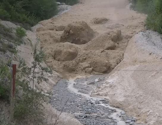
During the earthquake, somewhere near the headwaters of Gorst Creek, a mass of water-saturated glacial debris shook loose, liquified, and began moving downstream as a massive debris flow. The debris flow rolled down the creek, stripping vegetation from the banks and leaving a deposit of sandy material in its wake. It bulldozed over areas that had already been inundated by the tsunami and finally came to rest in Sinclair Inlet, dumping the rest of the material offshore. In some places, such as Otto Jarsted Park, the deposit left behind by the flow is 1.5 feet thick or more.

Illgraben debris flow video - The Landslide Blog - AGU Blogosphere
Debris flow rushing down a valley in the Alps, carrying large boulders. The debris flow that swept down Gorst Creek in A.D. 900-930 may have been similar, but probably did not carry large boulders, as there are none in the resulting deposit. Photo Courtesy of Youtube. 

Before the earthquake, the valley of Gorst Creek was forested with Western Hemlock and Red Cedar. A salt marsh with saltwater grasses marked the transition from Gorst Creek valley into the tidal zone, filled with oysters, mollusks, and clams in thick mud. Following the 900-930 A.D. Seattle Fault earthquake, the tsunami and debris flow had covered the tidal flat and salt marsh with nearly five feet of sand. Gorst Creek was filled with so much material that it likely transformed from a gently meandering stream to a sediment choked braided watercourse for a short period before flushing itself out.

Trash deposits alongside Fountain Creek in Pueblo, where high stormwater events force the stream bed to meander as large sediment volumes accumulate. - COURTESY PUEBLO CITY-COUNTY HEALTH DEPARTMENT
Following the A.D. 900-930 Seattle Fault Earthquake, tsunami, and debris flow, Gorst Creek may have looked similar to this. Courtesy Pueblo City-County Health Department

The sand layers deposited by the tsunami and Gorst debris flow can still be seen today in tidal channels along the bay, leaving stark reminders of the forces that wreaked havoc at the head of Sinclair Inlet 1100 years ago. Similar stories may exist elsewhere, yet to be discovered, but here at Gorst, the sediment record tells a story that presents itself as a clear and present reminder of the hazard that lies beneath our feet. Are you prepared? 

Monday, December 26, 2016

Reflections of 2004: Are you Prepared?

              Twelve years ago, as American kids were marveling at their new gifts they had received the day before, the earth jolted.
               Twelve years ago, as family members hugged goodbye, and planes were being boarded for the journey home. The ocean roared.
               Twelve years ago, as the rest of the world settled for a relaxing Boxing Day, the Indian Ocean Basin experienced an apocalypse.
               A section of the seabed over 800 miles long jerked to the west and upward in a titanic 9.2 magnitude earthquake that shook the countries of Bangladesh, India, Malaysia, Myanmar, Thailand, Singapore and the Maldives. Massive shockwaves rocked the ground for up to 10 minutes. People were thrown to the ground, buildings collapsed, sand boiled up like water from cracks. And that wasn’t the end.
               As soon as 15 minutes following the earthquake, tsunami waves up to 80 feet high careened into the coastlines, leaving a wake of death and destruction which took the lives of over 250,000 people around the Indian Ocean coast. It is one of the deadliest natural disasters in written history. And it wasn’t just a freak event.

The 2004 tsunami crashes to shore. Photo by Wikipedia. 

               In 2010, a magnitude 8.8 earthquake and resulting tsunami devastated the coast of south-central Chile. And in 2011, the northeast coast of Japan was ravaged by a 9.1 magnitude earthquake and massive tsunami which leveled entire towns. And in 2014 and 2015, Chile experienced an 8.0 earthquake which caused widespread damage each time.
               The twenty-first century is beginning to intimately introduce us to Megathrust Earthquakes. Huge events on Subduction Zones that can wreak havoc across half the planet. And while many countries around the world have experienced this cataclysm, the Cascadia Subduction Zone off our coast remains quiet.
               You’ve heard the spiel before, we’ve all read the New Yorker’s Post. So, I won’t go into the nitty gritty details of what nightmare fuel is waiting for us in our possibly near future (some seismologists put us at a 1/3 chance within the next 30 years). All I ask of you today, on the anniversary of the deadliest event of this kind is: Are you prepared? If not, here’s a couple links of how you could prepare for an earthquake in our area. Stay safe.

Ready to go.

Red Cross

FEMA Earthquake Checklist