Monday, April 13, 2020

Micah's Big Three

Once I take a liking to something, I tend to hyperfocus on it, sometimes to the point of obsession. This applies to hobbies, movies, food, books, and especially geologic features.

Over the past seven years, I have found three geographic features that have consistently captured my interest, bring me excitement, and that I love to talk about. Those three are geysers, waterfalls, and natural arches.

Geysers are the first feature that drew my attention. Back in 2012, I visited Yellowstone for a week and fell into the midst of the Geyser Gazers. Geysers instantly entranced me for their variation, patterns, activity, and uniqueness. I have now studied geysers and their associated hydrothermal features since, and it's something I plan to do for a long time.

Image may contain: one or more people, people standing, sky, cloud, outdoor, nature and water
The author observing an eruption of Beehive Geyser, photo by Cris Gower. 
The second geologic feature that ensnared me was an indirect result of geysers. In 2014, a good friend of mine talked two other friends and me into a three-day backpacking trip into a remote section of Yellowstone National Park known as the Bechler Region to view and photograph three world-class waterfalls. The trip was a chaotic blend of awesome and misery, but I came out of it with a new fondness of water going up as well as water going down. I kicked off the Kitsap Waterfall Survey just four months later.

No photo description available.
The author at "Tin Mine Falls", Kitsap County. Photo by Rocco Paperiello.
The third geologic feature is the most recent, and one that took me somewhat by surprise. This last Fall (2019) after the end of my Yellowstone summer employment, I took a road trip through central Utah. I always wanted to go to Utah to view its amazing geologic landscapes and formations. Several people told me before the trip that it would become my favorite state, and that I might gain another feature that I was obsessed with, arches. I laughed them off at the time, but that all changed when I actually got there. Natural arches joined the list, and now I take great joy in hiking to and photographing arches whenever the opportunity presents itself.

Author at Sand Dune Arch in Arches National Park. Photo by Rocco Paperiello. 
There is an interesting consistency when it comes to my enjoyment of these features. In all three cases, whether it be a geyser, a waterfall, or an arch, I always enjoy smaller features rather than big ones. I'm not sure why this is, perhaps I feel I can take in more details of these features. Take geysers as an example. I enjoy a massive 200-foot eruption as much as the next person, but you're almost detached, staring in awe at this gargantuan thing, trying to wrap your head around it. With smaller geysers (sub 20 feet), you are often closer, and they erupt more often, which allows you to get more in-depth with their formation and behavior. This same general concept applies to waterfalls and arches as well. I always gravitate towards the smaller features because I can get right up and close to them. "Wright Creek Falls" is one of my favorite waterfalls on the Kitsap Peninsula for this reason, as is Metate and Mano Arches in Grand Staircase-Escalante National Monument in Utah.

During this time that we're all jonesing for some good ol' outdoor exploration once it becomes sensible, think about some of your favorite geologic or geographic features and why that is. Then get out there and explore!

Tuesday, April 7, 2020

Drawing the Short Straw: Gorst's 900 A.D Devastation.

Every once in awhile there's a geologic story that just needs to be told.

I have been reading a series of scientific papers about the Seattle Fault. Many people who live on the Great (Kitsap) Peninsula know about the Seattle Fault. This crack in the earth runs east-west from Bellevue to disappear(?) under the glacial deposits west of Lake Symington. The Seattle Fault is capable of producing large earthquakes that shake the entire Puget Sound region, producing tsunamis, triggering landslides, and creating ragged scars across the landscape.

Seattle Fault Line
General map of the Seattle Fault. Map by the Kitsap Sun. 

Bounded on the north by the city of Bremerton, the Sinclair Inlet is one of several bays of the Great Peninsula. Basalt rocks of the Blue Hills meet the shore just west of the shipyard, while the south shore houses the city of Port Orchard. At the west end of Sinclair Inlet, where Gorst Creek kisses saltwater, is its namesake town, Gorst.

Aerial view of Sinclair Inlet looking west. The city of Bremerton lies in the center of the image. Gorst lies at the end of Sinclair Inlet near the top left corner. Image courtesy of Wikipedia. 
One winter day between A.D. 900 and A.D. 930, the entire Puget Lowlands experienced a 7.0-7.5 magnitude earthquake generated by the Seattle Fault, thrusting Gorst upwards by 9-15 feet. Uplift on the floor of Puget Sound spawned a tsunami that struck surrounding beaches, bays, and estuaries, including Sinclair Inlet. A train of waves, perhaps reaching close to 20 feet high, surged into the inlet and crashed ashore at the present-day townsite depositing a layer of sand and mud eight inches thick where cars and trucks are being sold today. According to computer modeling, the wave heights that Gorst endured were some of the largest that struck the Great Peninsula as a result of this event. But that wasn't the final blow.

During the earthquake, somewhere near the headwaters of Gorst Creek, a mass of water-saturated glacial debris shook loose, liquified, and began moving downstream as a massive debris flow. The debris flow rolled down the creek, stripping vegetation from the banks and leaving a deposit of sandy material in its wake. It bulldozed over areas that had already been inundated by the tsunami and finally came to rest in Sinclair Inlet, dumping the rest of the material offshore. In some places, such as Otto Jarsted Park, the deposit left behind by the flow is 1.5 feet thick or more.


Illgraben debris flow video - The Landslide Blog - AGU Blogosphere
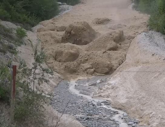
Debris flow rushing down a valley in the Alps, carrying large boulders. The debris flow that swept down Gorst Creek in A.D. 900-930 may have been similar, but probably did not carry large boulders, as there are none in the resulting deposit. Photo Courtesy of Youtube. 

Before the earthquake, the valley of Gorst Creek was forested with Western Hemlock and Red Cedar. A salt marsh with saltwater grasses marked the transition from Gorst Creek valley into the tidal zone, filled with oysters, mollusks, and clams in thick mud. Following the 900-930 A.D. Seattle Fault earthquake, the tsunami and debris flow had covered the tidal flat and salt marsh with nearly five feet of sand. Gorst Creek was filled with so much material that it likely transformed from a gently meandering stream to a sediment choked braided watercourse for a short period before flushing itself out.

Trash deposits alongside Fountain Creek in Pueblo, where high stormwater events force the stream bed to meander as large sediment volumes accumulate. - COURTESY PUEBLO CITY-COUNTY HEALTH DEPARTMENT
Following the A.D. 900-930 Seattle Fault Earthquake, tsunami, and debris flow, Gorst Creek may have looked similar to this. Courtesy Pueblo City-County Health Department

The sand layers deposited by the tsunami and Gorst debris flow can still be seen today in tidal channels along the bay, leaving stark reminders of the forces that wreaked havoc at the head of Sinclair Inlet 1100 years ago. Similar stories may exist elsewhere, yet to be discovered, but here at Gorst, the sediment record tells a story that presents itself as a clear and present reminder of the hazard that lies beneath our feet. Are you prepared? 

Wednesday, April 1, 2020

Kitsap County Geology: Green Mountain, Gold Mountain, and the Blue Hills.


I'm back. And no foolin'. 

The volcanic plateau of Yellowstone National Park that I call home is closed, set to reopen in the future at some as yet undecided date due to the pandemic sweeping the globe. I'm currently in Kitsap for the time being, socially isolating and eagerly awaiting any news. So during this lull, I got out the technological feather duster and opened this blog up after a...*quick mental math*... two-year absence. My sincerest apologies to devoted readers out there. 

Everyone in Kitsap County knows about Green Mountain, our forested little peak rising to an altitude of 1,710 feet, the second-highest peak on the Kitsap Peninsula. Gold Mountain to the south beats it out by 50 feet, reaching 1,761 feet. Green and Gold Mountains are the two highest summits in a cluster of hills referred to collectively as the Blue Hills. The Blue Hills is an official name accepted by the United States Geologic Survey, I would love for it to become common usage. Wishful thinking? probably, but you heard it here first!

Terrain map of the Blue Hills. on the Kitsap Peninsula. The city of Bremerton lies on the right side of the image. Kitsap Lake in the right-center. 
The Blue Hills emerge like the tip of a rocky iceberg from the center of the Kitsap Peninsula in a sea of glacial deposits. The glacial deposits have their own story, but that's a tale for another time. What are the Blue Hills made out of anyways? 

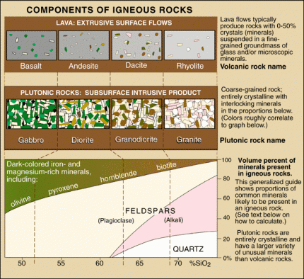
Components of Igneous Rocks
 (Click image to view full size.)
Chart from the USGS about igneous rocks and their mineral components. Surprisingly, you can find examples of almost every rock on this chart in the Blue Hills. 

The chart above illustrates different igneous rocks and their mineral components. Igneous rocks are rocks formed from magma or lava. If the rock is formed from magma below the surface, it is called an intrusive rock. If the rock is formed above the crust as a result of magma erupting onto the surface as lava, it is an extrusive rock. The Blue Hills are made up of both intrusive and extrusive rocks.

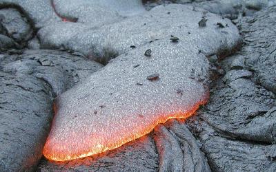
The primary rock composing the Blue Hills is gabbro. Gabbro is a coarse-grained, dark-colored, intrusive igneous rock made up mostly of the minerals plagioclase feldspar and pyroxenes. Gabbro is the intrusive equivalent of the most common extrusive volcanic rock on earth, basalt. Basalt is also present in large quantities in the Blue Hills. Gold Mountain is completely made of basalt, and the large rock outcrops you can see on the north shore of Sinclair Inlet alongside Highway 3 are basalt lava flows. Basalt from the eastern edge of the Blue Hils is mined and used in landscaping and construction purposes. Many of the rock retaining walls you can find around the Kitsap Peninsula were mined from the Blue Hills.

Hot basalt lava flowing over the surface of a cooled basalt lava flow.
 (Click image to view full size.)
A typical basalt lava flow. Photo by USGS. 

Following the emplacement of the gabbro and basalt of what would become the Blue Hills, the whole mass of rock was invaded by a swarm of structures known as dikes. Dikes are tabular or sheet-like bodies that intrude into existing rock units vertically or near vertically. When exposed they can look like narrow vertical cracks filled with volcanic or sedimentary material. Two kinds of rocks form the dikes that riddle the Blue Hills. Some of the dikes are andesite, a volcanic rock made up of mostly plagioclase, similar to basalt, but containing some quartz, which is rarely found in basalt. The other type of rock is dacite, another volcanic rock which has an even higher percentage of quartz than andesite (See chart above).

The final drop of "Gold Creek Cascades" goes over a dike of andesite. 
So, where can you see these rocks? Unfortunately, if there's one thing that Kitsap geology isn't, it's being easy to see. Right square in the center of the Pacific Northwest, our lush vegetation and vibrant growth hides most of the rocks from our sight. I already mentioned the most easily visible outcrop of rock in the county, the cliffs of basalt towering over highway 16 on the north shore of Sinclair Inlet. Aside from that, there are exposures of gabbro and basalt on the way up to the summit of green mountain, with the main viewing area (currently closed as of this writing) being built on the edge of a large basalt cliff. If you know the location of "school rock/turtle rock/eagle rock" on the south flank of Green Mountain, that is composed of gabbro. And there are a couple blink-and-you-miss-it outcrops of rock along the south side of Holly Road as it skirts the base of Peak 1291.

There are other stories to be told about the geology of the Blue Hills that I left out of this post for the purpose of time and the fact that scrolling for long periods is universally hated. I do plan to stay diligent though and see if I can get the flow going on this blog again. I can't promise multiple posts a week. But hopefully, something between 1-5 posts a month is what I'm shooting for. If there's one thing I love more than geology, it's telling other people about geology. And I've learned a LOT since I last worked on this blog. I think it's time to share some of that. Until next time!