Showing posts with label River. Show all posts

Sunday, May 8, 2016

Frenchman Coulee and Echo Basin, Overflowing the Bathtub

Time to play catch up It's a been a while.

Lets rewind the clocks back to 15,000 years ago. Our stage curtain opens with the northern hemisphere gripped in the frigid clutches of an ice age. Canada is completely smothered, the Puget Sound region is filled to the brim, and several tongues of ice extend down through north-central Washington, northern Idaho, and Montana. One of these lobes has blocked up one of western Montana's largest rivers, the Clark Fork. The pooling lake behind this icy blockade, named Glacial Lake Missoula by modern day geologists, has risen over 900 feet in some valleys. The location of downtown Missoula, Montana is now resting at the bottom of a body of water dwarfing any lake in the western US today.

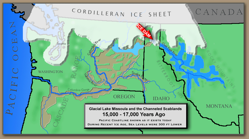
Map showing the location of Glacial Lake Missoula and the path of the ice age floods. 
But then, something happened, a catastrophic event that rearranged the face of eastern Washington forever. The ice dam holding back Glacial Lake Missoula breached. A massive wall of water, filled with icebergs, boulders, trees, tore through the narrow river valleys of the Idaho panhandle and plowed into another huge glacial lake resting over what is now Spokane and extending northwest. But even this huge glacial lake was not enough to halt the flow of this sudden rush of water, the second lake also breached and the floodwaters made their way to the Columbia River the fastest way they could, through the Columbia River Basalts.

The Columbia River Basalts, were formed 18-15 Million Years ago when the Yellowstone Hot Spot began it's chain of cataclysmic explosive eruptions in southwestern Idaho. The basalt flows covered 40% of Washington State in a flat plateau up to 3 miles thick. But as sizable as this blanket of rock was, it hardly slowed the raging water down.

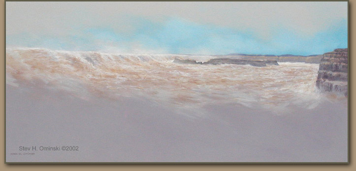
Artist's rendition of what the floods may have looked like as they flowed through the Grand Coulee. 

The incredible force of the gargantuan torrent ripped into the basalt rock with vengeance, scouring huge, square-shaped canyons, or "Coulees", into the bedrock as it flowed towards the Columbia. However, at a certain point during its journey, it paused. One branch of the flood encountered the basin of an ancient lake, a geologic bathtub perched high above the eastern shore of the Columbia. The water was temporarily halted as it filled the lake basin, but the volume was too much. Eventually the flood spilled over the western rim of the bathtub.  Huge waterfalls, unlike anything the world has ever seen today, crashed over cliffs hundreds of feet into the waiting maw of the Columbia's canyon. As the volume of water going over the falls increased, the waterfalls migrated backwards, eating their way through weak layers of columnar basalt flows, picking away individual columns like straws; Frenchman Coulee was being born. At the same time slightly further to the south, Echo Basin, a huge amphitheater carved into the same lava flow as Frenchman Coulee, was also forming. Eventually, the headwalls of these spectacular basins, now used as a playground for hikers and rock climbers, and prime rattlesnake habitat, were worn back to the point where they remain today.

Looking out over Echo Basin on the edge of the Columbia River canyon (Background). Note the prominent Basalt Columns on the right side of the image. Photo by Micah K. 

Tuesday, April 5, 2016

Geomorphology of the northern Thorp Region

The small hamlet of Thorp, Washington, lies about 14 minutes to the west of Ellensburg as the cwu geology van drives. It is located in the Yakima River Valley, the namesake of which meanders it's way north of Thorp slowly making it's way southeast. 

Today I ventured out on a field trip with my Geomorphology class to observe some of the Geomorphological features of the area. What is Geomorphology? Just break it up! Geo=Earth, Morph=Change, and Ology=To Study. So putting it all together, it's the study of landforms created through geologic processes. 

The first feature we observed was the most interesting to me personally. Almost 2.8 miles due north and a little west of Exit 101 on Interstate-90, is a large hillside comprising of ancient Yakima River Sediments. At this point, 1.5 to 5 thousand years ago, the hillside failed. Possibly driven by weak clays or saturated soils, a massive rotational-slump type landslide broke loose. The resulting earth flow at the foot of the slide shoved the Yakima River south by several hundred feet. 

Looking across the large landslide north of Thorp. Photo by Micah K. 

From an overlook at the western edge of the landslide, my Geomorphology class looked across this landslide. The displaced material had taken on a hummocky appearance, with the blocks tilted slightly towards the failure headwall. The size of this thing was boggling, even while small in comparison with the landslide that, for example, decapitated Mount Saint Helens in 1980 with catastrophic results. Even the several houses that were built on top of the landslide deposits seemed small in comparison. It was truly amazing.

Northwest of Thorp, Interstate 90, climbs up another large slope and across the wide, rolling expanse of basalt boulders and sagebrush known as the Thorp Prairie. It's strangely empty up on this expanse, only being occupied by several old and dilapidated windmills, and crisscrossed by irrigation canals. The reason for this emptiness being most in part for it's geology. Thorp Prarie sits on a massive terminal moraine formed many thousands of years ago when a large glacier flowed down the Yakima River Valley. The heart of this moraine is filled with rocky glacial garbage, scraped out from the mountains and dumped here as the glacier retreated, too rocky to farm on, and not very suitable for irrigation, this, it has remained relatively untouched. 

As the Yakima River carves it's way through this moraine to the north, over thousands of years it has created several large flood terraces visible on the flank of the moraine and elsewhere in the valley walls. These large flat expanses are sometimes built directly on top of Columbia River Basalt, which is exposed in the deepest parts of the canyon by the river. And as luck would have it, I'm going to see a important portion of the Columbia River Basalt tomorrow. So...to be continued......

Erosional Remnant of the Columbia River Basalt. Photo by Micah K. 


Sunday, April 3, 2016

Coming full circle, The surprising relation between Kitsap Waterfalls and Yellowstone Geysers.

It's no secret that my two favorite things on this earth are Yellowstone's hydrothermal features and the Kitsap Peninsula's hidden waterfalls. One takes my attention during the summer, the other takes my attention during the wetter months of the year. Two separate geological features, nearly 900 miles apart, with seemingly no relation between them. Or so I thought...

I have just finished wrapping up my first week of classes here at Central Washington University, and am loving it. My classes are fascinating, my professors are great, and it's looking like the quarter is going to be one adventure after the other.

During on of my classes, "The Geology of the Pacific Northwest" this week we were discussing two of Washington's major geologic events. The Columbia River Basalts, that covered 40% of the state in up to 3 mile thick layers of lava rock. And the huge glacial floods that tore their way out of Montana and roared across the flat plateau of eastern Washington, all the way to the Pacific.

The origins of the Columbia River Basalts were 18 million years ago when the Yellowstone Hot Spot made it's first continental appearance, tearing massive calderas into what is now northwestern Nevada, southeastern Oregon, and Southwestern Idaho. For years I had thought that these first explosive eruptions were the birth of the Yellowstone Hot Spot. When I asked my professor this, he informed me that recently it had actually been suggested that the Yellowstone Hot Spot is much older, and has been erupting for longer than is commonly thought.

As it turns out, there are several studies which show the Yellowstone Hot Spot originating off the ancient west coast of the Pacific Northwest. For those of you who have been to my waterfall lecture, something should begin to feel eerily familiar about this....

As I explained in my lecture, 55-57 million years ago, some unknown force split the ancient Farallon Plate into several pieces and erupted a huge amount of basalt lava onto the seafloor. These basalts, today known as the "Crescent Formation," were slammed into the side of the North American Plate and stuck there, uplifting to become modern day Vancouver Island, part of the Oregon coast ranges, the eastern Olympic's, and the core of the Kitsap Peninsula. It is now believed that the "unknown force" was none other than the Yellowstone Hot Spot. That's right, the bedrock comprising Green and Gold Mountains, and the rest of the Blue Hills, the same bedrock that our beloved waterfalls crash over, probably originated from the geological feature which fuels Old Faithful, Beehive, and the other 1500 geysers in Yellowstone National Park.